
Monday Morning Weather Brief | July 21, 2025
Good Monday morning and welcome to the new work week!
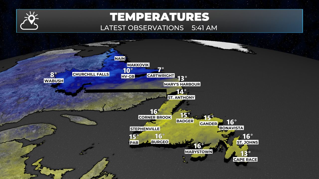
We are starting off the day with temperatures across the Island in the mid-teens, while slightly cooler readings closer to 10º are found across the Big Land. Here is a look at the Province-wide temperatures as of 5:41 AM NDT (5:11 AM ADT).
Temperatures today will not move upward all that much across the Island due to copious amounts of cloud cover from an inbound low which is currently located south of the Province. (Tap to see the forecast)


The forecasted low is already driving rain and rain showers across much of the Island. The heaviest rain at this hour is located over the western half of the Island.
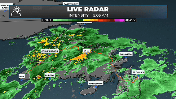
MORNING RADAR LOOP
Radar loop between 2:45 AM and 5:45 AM NDT on July 21, 2025
The rain will becomore more widspread over the Island later this afternoon and overnight as the low becomes better organized. In fact, some very heavy rainfall is expected over northeastern Newfoundland overnight which is excellent news for the fires burning in Chance Harbour and Musgrave Harbour. The rain we see overnight into Tuesday will be the most we’ve seen in quite some time over such a large area. Futurecast, below, illustrates how this will unfold today.
Rainfall amounts will be in the 20 to 40+ mm range from near the Connagire Peninsula northward toward Bonavista Bay. This is great news for both the Chance Harbour and Musgrave Harbour fires as the rain should do a great job of really knocking them down and hopefully putting them out entirely.

Another benefit of the low-pressure system is a complete shift in wind direction from south and southeast to north and northeast. This will blow each fire back on areas it has already burned, and once again should help in the suppression efforts. The thing is that wind shift will not occur until later today and tonight, and as the wind swings from southwest to northeast, it will have to go through the compass. Meaning gradual changes to south, southeast, east, and eventually northeast late tonight. That may push smoke and/or the fire in Musgrave Harbour closer to the community. However, ahead of the wind shift, the wind speeds will be much lighter today than Saturday and Sunday. The shift is forecast to occur. Here is the wind speed forecast for the next 24 hours for the northeast coast.
My full forecast for the week will be up later today. Meanwhile you can track the rain yourself in the Sheerr Weather app and in the Map Room!