
Monday Morning’s Weather Briefing — March 30, 2026
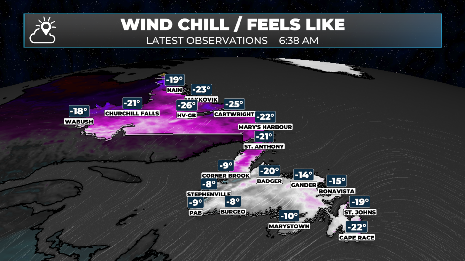
Wind chills as of 6:38 AM NDT (6:08 AM ADT)
Good Monday morning!
Here are today’s weather highlights:
Areas of flurries and pockets of light snow will be found across much of NL today.
A fast-moving low moves through of Strait of Belle Isle overnight, and brings snow and some rain to Newfoundland and parts of Labrador into early Tuesday morning.
Winds gusts will be as high as 80 km/h along the South Coast, Burin and Avalon Peninsulas and around the northeast coast overnight from the south. There is a chance the Avalon will see gusts to 100 km/h early Tuesday.
Another weather-maker arrives Wednesady and has the potentail to bring significant snow and ice to the Burin and Avalon Peninsulla and some adjance tareas into Thursday morning.
Today’s Forecast
An area of low pressure will begin to develop over eastern Quebec today. As a result, flurries and pockets of light snow are expected to form across much of Newfoundland and parts of Labrador as warm air is lifted over the very cold, dense air in the region. This lifting mechanism is the main factor driving what we will observe today. Therefore, throughout the province, expect high temperatures to stay below freezing and skies to range from partly cloudy to generally cloudy, with more clouds than sunshine expected by the afternoon.
NL's forecast for today, March 30, 2026
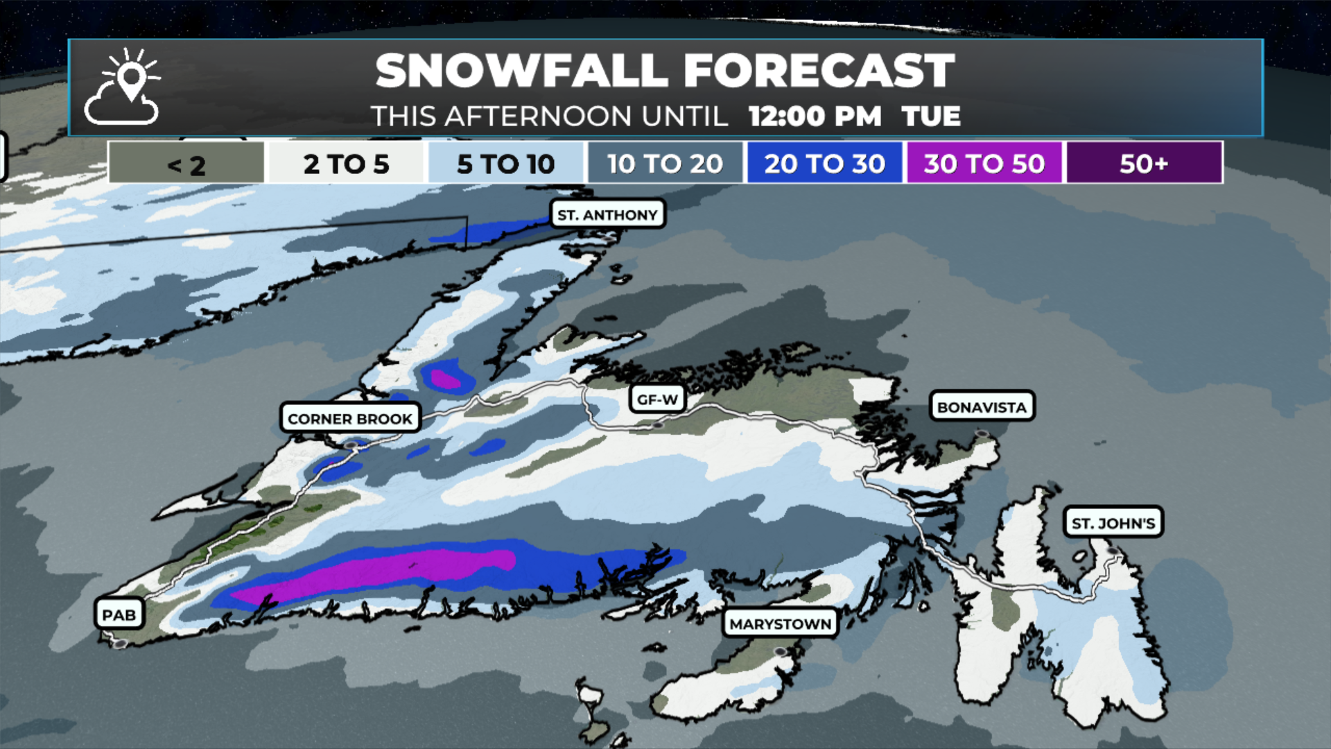
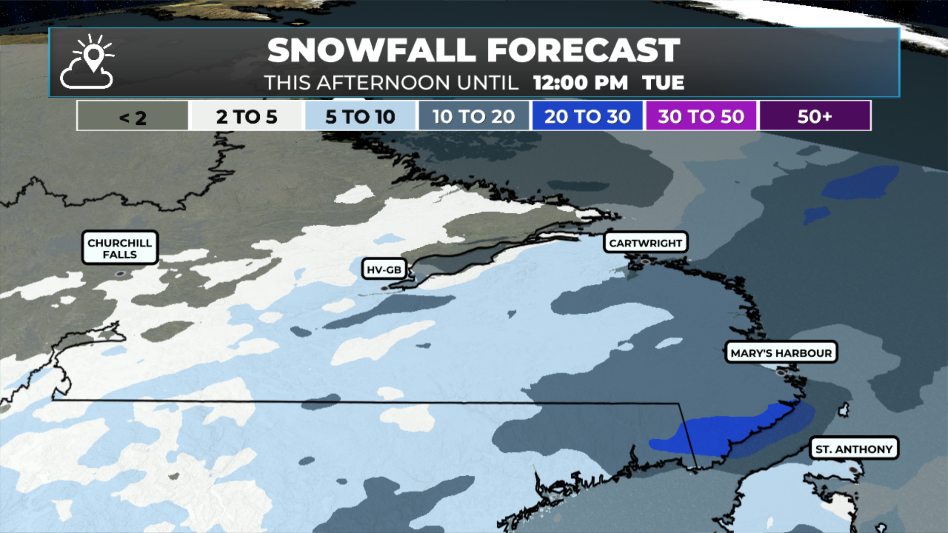
The same area of low pressure will move along the Lower North Shore of Quebec overnight into early Tuesday. Expect snow to fall over southern Labrador and much of the Island overnight as the low passes through. Over the Avalon and Burin Peninsula, the snow will change to light rain or drizzle before ending Tuesday morning. Future radar and satellite images show this scenario playing out clearly.
Snowfall amounts for most regions will not be significant, with a widespread 5 to 10 cm (or less) expected. The exceptions will be along the southern shorelines of the Island, particularly the South Coast, where snowfall could reach up to 20 cm. The same applies along the West Coast in higher terrain and in the Labrador Straits. Although this system won't be overly windy, most areas will experience gusts of 70 or 80 km/h from the south. There's a chance the Avalon could see gusts of up to 100 km/h early tomorrow morning.
The weather will improve Tuesday behind this departing area of low pressure. Then my attention will turn to Wednesday. An elongated area of low pressure will just south of Newfoundland between Wednesday and Thursday morning. This will set the stage for the potential of significant snow and ice over southern and southeastern Newfoundland in the time frame, and more specifically the Avalon and Burin Peninsulas. As of this morning, it appears as though snow will arrive Wednesday morning and there will be several hours of it. The snow will then change to ice pellets and freezing rain Wednesday afternoon or evening and will continue into early Thursday. While it’s too early to get into amounts, there is the potential of significant amounts of snow and ice build-up from freezing rain in the time frame.
An animation of what to expect Wednesday into Thursday (April 1 to 2, 2026)
This is one of those situations where small changes in track can mean the different between 10 cm of snow and 10 mm of freezing rain and 20 cm of snow and very little freezing rain. I’ll have a more thorough update on this and the rest of the week’s weather this afternoon.
FIND ME ON SOCIAL!