
Wednesday Morning’s Weather Briefing — August 12, 2026
Good Wednesday Morning! Here are some highlights for the day(s) ahead:
There are areas of showers and pockets of rain over western regions and the Northern Peninsula this morning.
It’s muggy to start the day, and it will stay that way. Humidex values near 30 in centra/eastern Newfoundland this afternoon.
Chances for showers and thunderstorms remain moderate across much of the Island later today.
Fog and drizzle along the south coast will clear from west to east later today as a drier air mass moves in.
The weather improves across NL for Thursday as today’s low departs.
This morning’s update is sponsored by Roebothan, McKay, Marshall.

Visit MakeTheCall.ca today to learn more about how the law firm can help you!
Good Wednesday morning!
There are two weak areas of low pressure near/in the Province this morning. One is located to the east of Labrador, and another is right over the Island. The second is going to be the main weather-maker today. We are seeing a band of showers near the west coast and Northern Peninsula, along with drizzle and patchy dense fog across most of southern Newfoundland. A few of those showers will turn into rumbles of thunder through the day, especially across and into Central. In fact, much of Newfoundland has a chance of seeing some thunderstorms this afternoon as the atmosphere destabilizes near the inbound low.
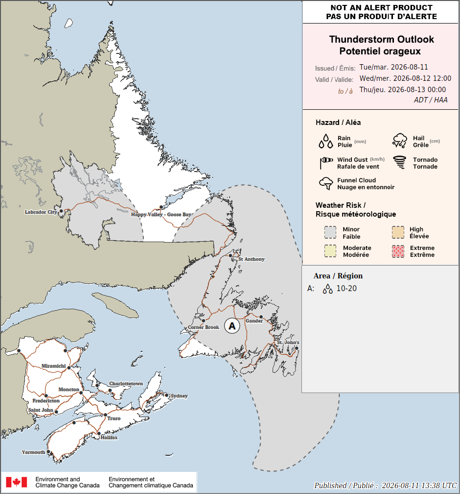
Today’s thunderstorm outlook from Enviornment and Climate Change Canada. August 12, 2026
Overnight temperatures held in the mid to upper teens across most of the Island, and that’s where we are going to start the day. It’s also feeling much more humid out there, with dew points already in the mid-teens. Temperatures will climb into the 20s today, and humidex values will be close to 30 in some areas that see the warmest highs.
Newfoundland’s forecast for today - August 12, 2026
Eastern Newfoundland and the Avalon: Partly to mostly cloudy. Scattered showers and a chance of a thunderstorm move in later today, with highs in the low-to-mid 20s. Warmest well away from the water; coastal spots near south-facing shores will run cooler with any onshore breeze. There will be areas of fog to the south as well. The Humidex is expected to close in on 30 this afternoon in the warmest areas.
We may just have decent weather for viewing the eclipse after all!
Central/Northeast Newfoundland: Partly to mostly cloudy with showers and thunderstorms likely today, especially this afternoon. Highs near 24. The Humidex peaks in the upper 20s. This is the area most likely to hear some thunder today.
West Coast: Generally cloudy with scattered showers, pockets of rain and isolated thunderstorms. Highs near 20 with humidex values reaching the mid 20s.
South Coast: Morning showers ease off through the day, highs around 19 to 21. Any fog should begin to clear as the wind changes from south to west.
Southwest/Wreckhouse: Mostly cloudy, highs 18 to 20. Winds gust up to 60 in the Wreckhouse this morning — breezy, but nowhere near warning territory.
GNP and the Straits: Rain lingers here longer than most spots, highs only 16 to 18, and it'll stay slow to clear given the fog and onshore flow. Especially along and near the east-facing shores.
Labrador’s forecast for today - August 12, 2026
Labrador: The Big Land stays mostly dry today. Lab West sees a thunderstorm risk with highs 17 to 19, Central (Goose Bay) is cloudy and 18 to 20, and the North Coast around Nain is mostly cloudy and cooler at 12 to 14. The southeast corner of Labrador is the exception, where rain will become widespread this afternoon. Highs reach the upper teens to lower 20s.
Hang in there — this pattern doesn't stick around. High pressure builds in behind today's system, and Thursday looks like the pick of the week: sun returns, and highs jump into the low-to-mid 20s on the Island (St. John's could flirt with 25!). Enjoy it!
My next update will be posted later today!
FIND ME ON SOCIAL!
