
Wednesday morning update — August 13, 2025
Good Wednesday morning. The Provincial Government will be holding an update on the fire situation at 10:00 AM this morning. View it here.
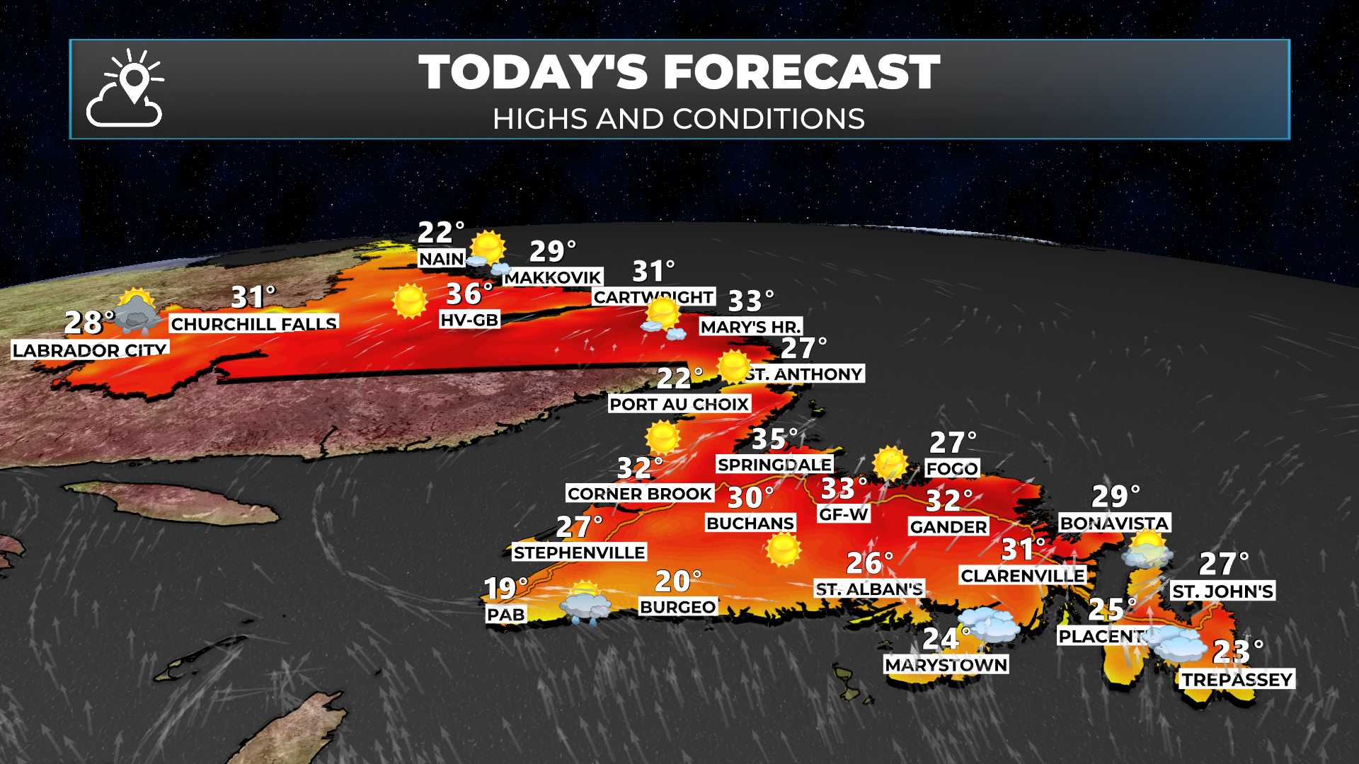
We are beginning the day with temperatures in the teens and 20s across the Island and generally teens in Labrador. Today is going to be another hot day across much of the region as our Heat Dome remains firmly in place.

Heat Warnings remain in effect for much of Newfoundland and parts of southeast Labrador and Upper Lake Melville. Afternoon highs will again be in the upper 20s to lower 30s for many areas.
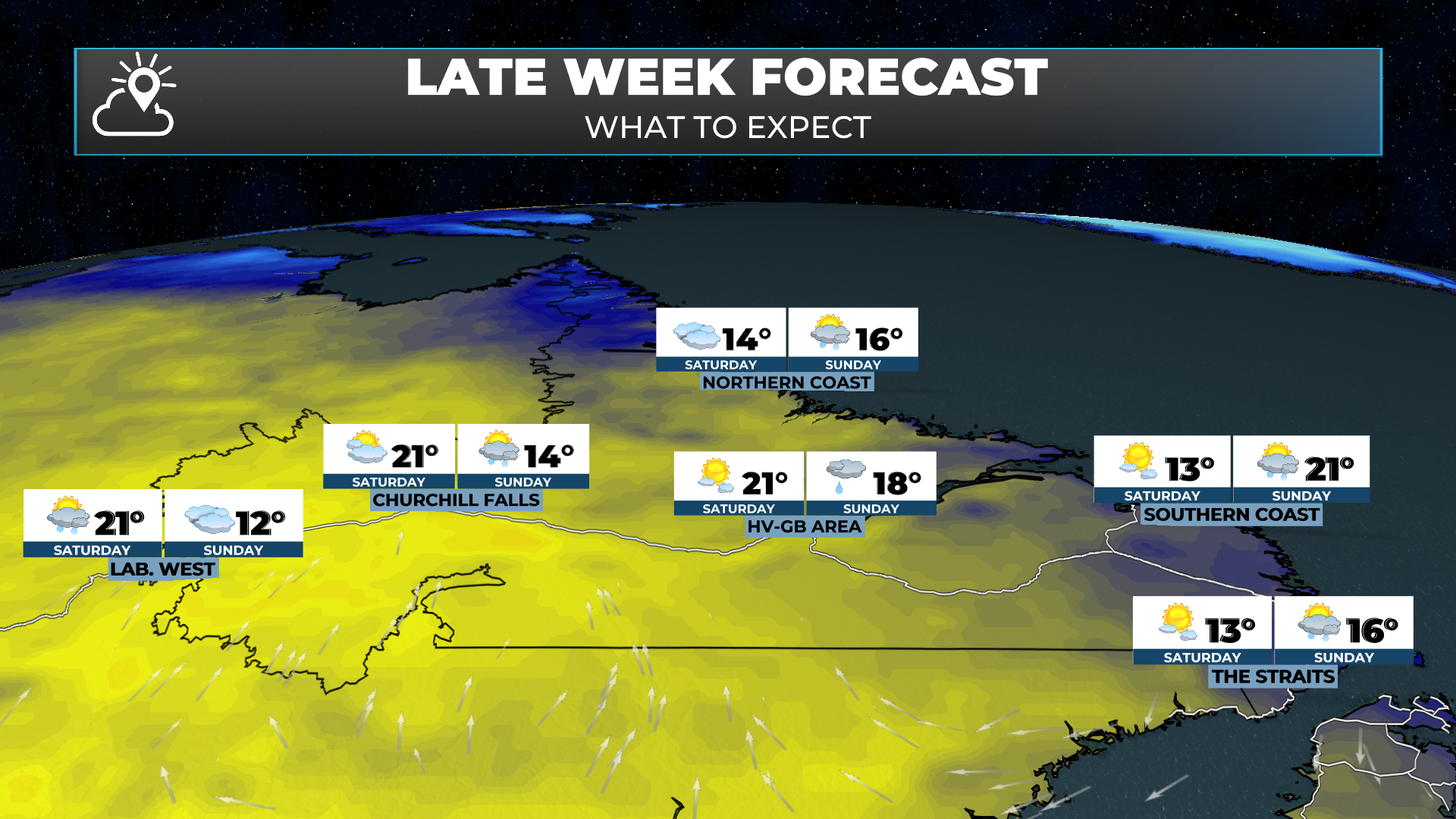
A cold front is expected to begin sweeping through Labrador on Thursday. This will break the heat in all areas but the southeast, where you’ll have to wait until Friday. Along this front, there will be some showers and thunderstorms.
Today’s forecast is brought to you by Roebothan, McKay and Marshall.

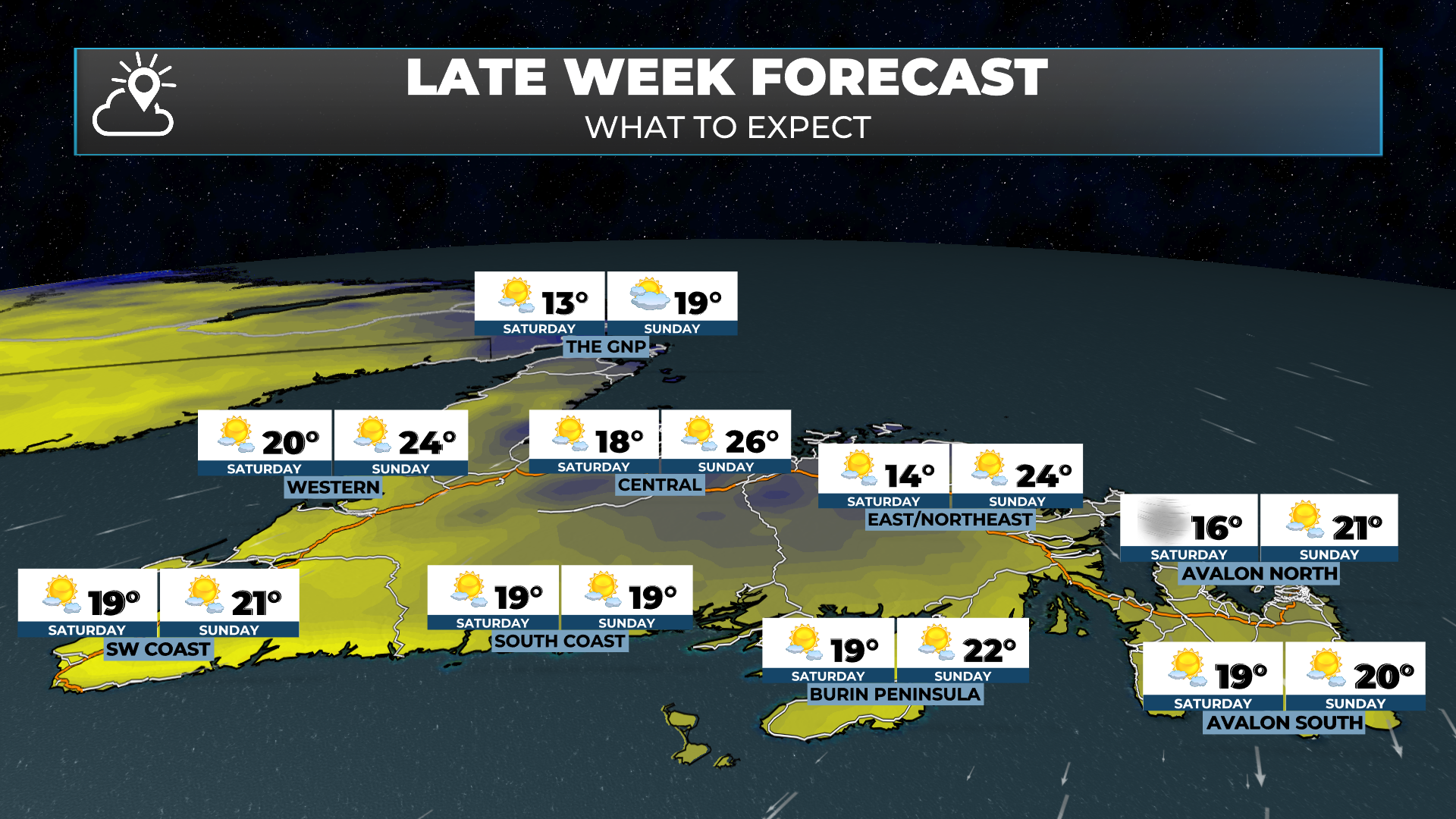
That same front is going to move across the Island Friday into early Saturday. This will put an end to our extremely hot weather for the time being. Rain showers and possible thunderstorms will accompany the front as it passes. The best chance of heavy rain and storms will be on the West Coast and the Northern Peninsula. Areas of central and eastern will see some rain as the front passes, but amounts now look rather light. It will not be enough to put out the fires.
Behind the front on Saturday, an area of high pressure will set up in the Gulf of St. Lawrence. This will turn the winds northerly for eastern and northeastern Newfoundland, bringing down temperatures and increasing humidity near the north-facing shores. Regarding the fires, this will substantially hinder any new growth. Warmer temperatures return for Sunday and Monday, but we’re talking lower to mid-20s and not 30s.
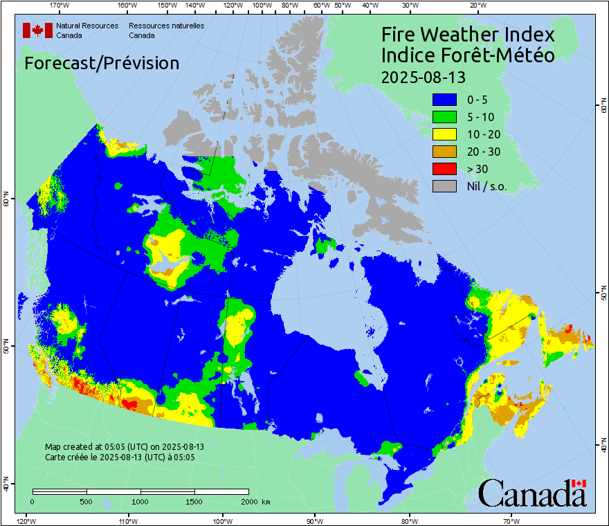
FIRE WEATHER FORECAST
Today will be another challenging day battling the three out-of-control fires on the Island. It will be the same in Labrador for the out-of-control fire between Postville and Hopedale, as well as the held fire south-southwest of Happy Valley-Goose Bay.
Much like yesterday, the Fire Weather Index is listed as 20 to 30 or 30+ for a good chunk of Newfoundland and Labrador. A Canadian Fire Weather Index (FWI) near 30 signals extreme fire danger, meaning conditions are highly conducive to rapid fire ignition and spread. At this level, even small sparks can quickly lead to fast-moving, intense wildfires that are very difficult to control.
Coupled with this is another measure that can be looked at for the rate of fire spread, called the Head Fire Inensity, or HFI. Much like yesterday, values over eastern Newfoundland and parts of Labrador will be in excess of 10,000 kilowats per metre. The image is displayed below.
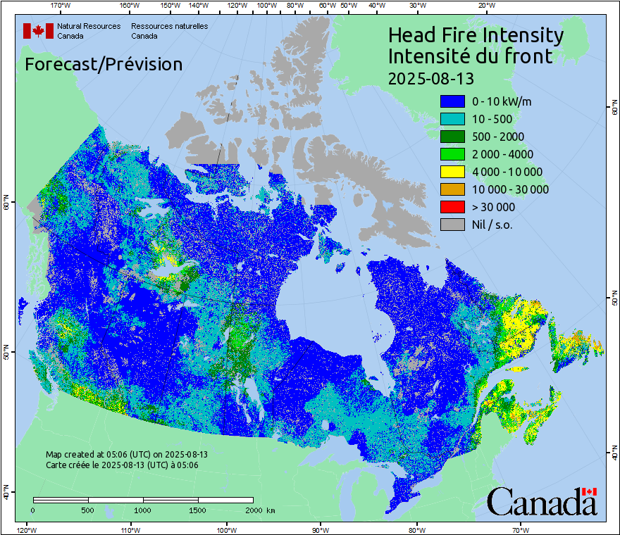
An HFI value in the 10,000–30,000 kW/m range (orange on the map) means an extremely intense fire front capable of producing flames over 10 m high, generating its own wind, and spotting far ahead of the main blaze. Fires at this level are unsafe for direct attack, often forcing crews to focus on indirect containment strategies and structure protection rather than head-on suppression.
So what does this mean for you?
This means that the Martin Lake Fire, Kingston Fire, and Paddy’s Pond Fire are all likely to continue growing today and will be extremely hard to fight with suppression resources. They are expected to produce a significant amount of smoke, which will impact air quality in the vicinity of these fires. The St. John’s area will likely be impacted most by poor air quality. The fires are likely to become more active this afternoon and late in the day, as we have seen repeatedly.
I am hopeful that an increase in humidity over the next couple of days will help slow the growth and growth potential of these fires.
OVERNIGHT FIRE GROWTH
MARTIN LAKE FIRE
The Martin Lake Fire grew substantially to the north of Martin Lake and is now not far from the Bay d’Espoir Highway. The Highway is currently closed near Bishop’s Falls, and northbound, the highway is closed well south of the fire location. Check 511NL.ca for the most up-to-date information.
I expect more growth today toward the northeast and eventually north today and tomorrow as the wind direction turns more southerly. This will continue to impact the Bay d’Espoir Highway. Cabin owners EAST of the highway who may not be in an evacuation alert zone MUST be ready to evacuate today.

KINGSTON FIRE
The Kingston Fire also grew overnight. The growth appears to be concentrated in the Smooth Cove area. Today I fear there will be significant growth in the Northern Bay area.

The current evacuation orders go from Small Point–Adam’s Cove–Blackhead–Broad Cove, Kingston, Western Bay, Perry’s Cove, Ochre Pit Cove, Salmon Cove, Burnt Point-Gull Island-Northern Bay. Evacuation Alerts may be extended into Job’s Cove, Lower Island Cove, and Caplin Cove if they haven’t already been. The wind direction will become more southwesterly today and then southerly tomorrow. This will push the fire toward the north.
PADDY’S POND FIRE
The Paddy’s Pond fire held on the north side overnight. This is not surprising, as the wind has been blowing from the west or west-southwest. And the fire cannot grow much to the east because the pond is in the way, so the only option is for northward and southward expansion.

Today I am expecting to see more fire growth on the north side as the wind direction will become more southwesterly. Meaning the wind is flowing from the southwest to the northeast. Wildfires move in the direction they’re getting pushed. The wind will turn more southerly overnight and on Thursday, and will also increase in speed. This will cause further growth on the northern flank of the fire tomorrow. The wind direction will turn more southwesterly again on Friday before going north on Saturday.
For those of you in the Evacuation Alert areas of Conception Bay South, Paradise, Galway, and Southlands closest to the fire, it is VERY important that you have whatever is most important to you together NOW, in case an evacuation order is issued today, tonight, or tomorrow.
WILDFIRE INFORMATION RESOURCES
GOVERNMENT OF NL ALERTS WEB PAGE
GOVERNMENT OF NL FACEBOOK PAGE