
Tuesday’s Morning Weather Briefing — July 14, 2026
A PROVINCE WIDE FIRE BAN REMAINS IN EFFECT UNTIL JULY 17 ....
A PROVINCE WIDE FIRE BAN REMAINS IN EFFECT UNTIL JULY 17 ....
Good Tuesday Morning! Here are some highlights on the day(s) ahead:
Areas of rain and showers will persist along and near the West Coast and into parts of Green Bay-White through the day. The rain will be heavy at times. The rain will ease this afternoon or evening.
Expect scattered showers on the GNP and into parts of Central.
Some of the rain showers will be quite heavy.
Afternoon showers and thunderstorms will once again roll into Labrador West south of a low. Those will move into the Churchill Falls area and Goose Bay later today and by evening.
Highs reach the teens to near 20ºC on the Island and teens to middle 20s in Labrador.
Another low swings in on Tuesday night and Wednesday, bringing more rain, showers, and storms to the Province. This same low will bring areas of dense fog to southern areas in the same time frame.
This morning’s update is sponsored by Roebothan, McKay, Marshall.

Visit MakeTheCall.ca today to learn more about how the law firm can help you!
All of this ties back to a broad area of low pressure sitting over Quebec that's been dragging a slow-moving band of wet weather into the Gulf of St. Lawrence and up against western Newfoundland. When that kind of onshore, moisture-laden flow runs into the Long Range Mountains, it wrings itself out — that's exactly why Corner Brook and Gros Morne are dealing with soe of the highest rain totals in the last 24 hours or so. A separate, much deeper low sitting well to the north over the Hudson Strait/Baffin Island area isn't a direct player for the Island, but it's the reason Labrador's North Coast is stuck in cool, cloudy northeast flow while everywhere else warms up.
TODAY’S FORECAST
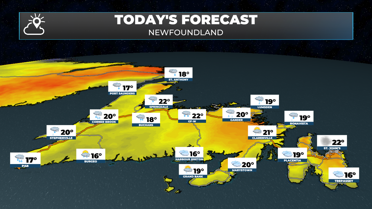
Newfoundland Today
The Rainfall Warning for Corner Brook and Gros Morne has been ended — the heaviest rain has moved through, and what's left behind is scattered showers that will keep easing off through the afternoon and evening. Green Bay-White Bay picks up the tail end of the same moisture, with showers running heavy at times early before tapering off this evening. Highs there stay in the upper teens under lingering cloud.
Central Newfoundland is riding out the tail end of overnight rain this morning, gradually shifting to scattered showers as the day goes on, with highs near 20ºC. The GNP and the Straits see a similar scattered-shower setup, breezy out of the southwest.
The South Coast, around Burgeo, and the Southwest/PAB area both stay unsettled too — showers on and off through the day, with a brisk south wind picking up in the Wreckhouse corridor, and a chance that showers there turn into a thunderstorm overnight as the next system starts nosing in.
The Avalon and the rest of eastern Newfoundland are the exception today — mostly cloudy but dry, breezy out of the southwest, and holding onto highs near 20ºC. Enjoy it, because this is the calm before tomorrow's system.
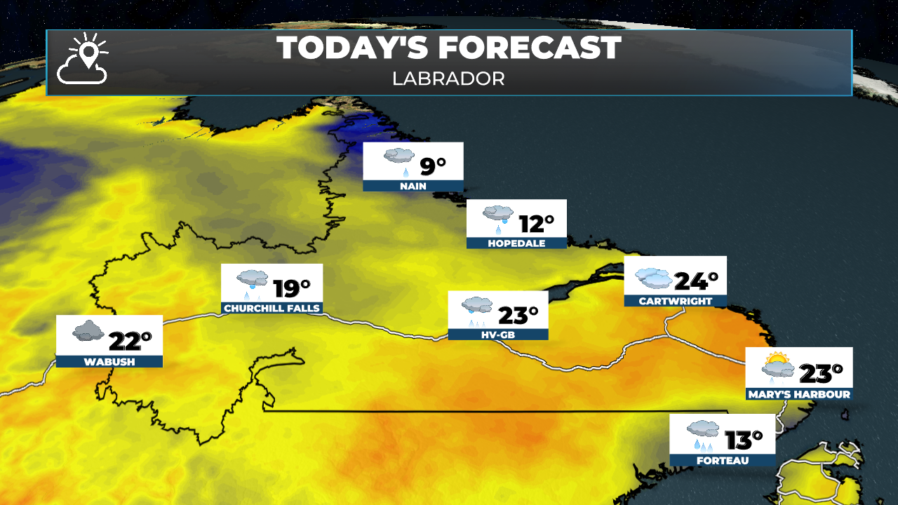
Labrador Today
Labrador West sees another round of afternoon showers, and thunderstorms fire up south of that low, and those will track east into Churchill Falls and eventually reach Goose Bay by evening. Highs there run into the low-to-mid 20s ahead of the rain — genuinely warm air, which is part of what's fueling the thunderstorm risk.
The North Coast is a completely different world today. Nain and the surrounding area stay locked under thick cloud in a cool northeast flow off that Hudson Strait low, with highs only near 10ºC — 10 to 13 degrees cooler than the rest of the province. It'll feel more like a raw fall day than mid-July up there.
Looking Ahead
The next low swings in tonight and carries through Wednesday, and it's not messing around — expect another round of rain, showers, and a few storms across the province. This system also looks set to drag dense fog into southern areas, especially exposed and south-facing shores, as milder, moist air runs over cooler water and coastline ahead of it. St. John's and the Avalon, which stayed dry today, get caught by this one — expect a windy, soaking rain by Wednesday afternoon with gusts potentially over 65 km/h. There's also a real chance this wet pattern out west doesn't fully let go, and eastern Newfoundland could see a repeat performance later in the week, so keep that in mind if you've got plans.

My next update will be posted later today!
FIND ME ON SOCIAL!
