
Tuesday Morning’s Weather Briefing — July 7, 2026
Temps across NL as of just before 6:30 AM NDT
Good Tuesday Morning! Here are some highlights on the day(s) ahead:
A ridge of high pressure builds across the region for the next 48 hours, bringing some of the warmest temperatures of the summer. Highs across NL reach the mid-20s to low 30s for many areas.
Skies will be sunny across much of the Province through the day!
It will be cooler in areas of onshore winds - west/northwest at 20 to 40 km/h.
A Heat Warning is in effect for parts of Labrador - check the ticker above for locations, go here.
Stay cool today and remember to drink plenty of water!
This morning’s update is sponsored by Roebothan, McKay, Marshall.

Visit MakeTheCall.ca today to learn more about how the law firm can help you!
Newfoundland
A ridge of high pressure builds in across the Island through the next 48 hours, setting up some of the warmest air we've seen all summer. Highs will range from the mid-20s to near 30ºC across many areas, with sunshine dominating the sky for most of the day.
Not everywhere gets the full warmth, though. Where onshore flow sets up — west to northwest winds running 20 to 40 km/h — temperatures will hold noticeably cooler, particularly for coastal stretches of the West Coast and the Northern Peninsula that catch that wind direction most directly. Central NL and areas tucked away from the coast are more likely to see the higher end of the range.
With numbers like these, take it easy in the heat of the day. Stay in the shade when you can, and drink plenty of water.
Newfoundland’s forecast for today — July 7, 2026.
Labrador
The same ridge extends its reach into the Big Land, pushing temperatures up across the region over the next two days. A Heat Warning is in effect for parts of Labrador — check the ticker above for the specific communities included, or head here for the full list.
Skies stay mostly sunny through the day, and like on the Island, spots that pick up onshore wind flow will run cooler than areas sheltered from it. HVGB and area, along with the rest of the Big Land, should plan for the heat to build rather than ease over the next 48 hours.
Labrador's forecast for today — July 7, 2026.
Today’s Fire Hazard Index
The Canadian Wildland Fire Information System Fire Hazard Index shows parts of Newfoundland in the ‘very high’ category. The Provincial index (from yesterday) has yet to reflect this change. Keep in mind these are different products. In my opinion, it’s very important to NOT have any open fires today if you’re in an area rated as high to extreme on the CWFIS map below. The combination of heat and dry air makes fire danger very high in many areas today. Remember, there is currently a fire ban in Labrador due to the ongoing wildfires. Find the Provincial info here.
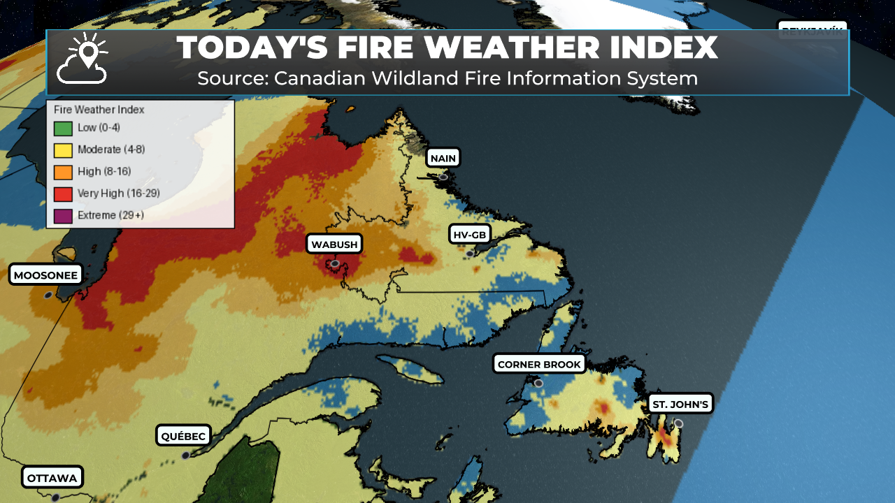
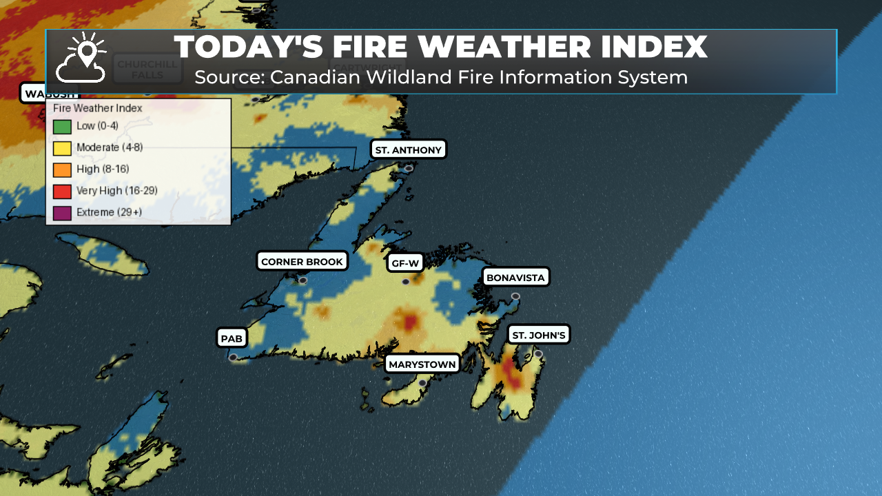
Fire Weather Index (FWI) rates how easily fire can spread and how much fuel it can consume, based on temperature, humidity, wind, and rainfall. Higher values mean drier fuels and more dangerous fire behavior.
0–5 (Blue) — Low: Fires start and spread slowly; easy to control.
6–15 (Yellow) — Moderate: Fires spread at a moderate rate with some intensity.
16–22 (Gold) — High: Fires spread quickly and burn more intensely; harder to control.
23–29 (Orange) — Very High: Fast, intense spread; significant control challenges.
30+ (Red) — Extreme: Explosive, aggressive fire behavior; very difficult or unsafe to attack directly.
My next update will be posted later today!
FIND ME ON SOCIAL!
