
Tuesday Morning’s Weather Briefing — April 21, 2026
The snapshot of NL weather for today - April 21, 2026
Good Tuesday morning!
Here are today’s weather highlights:
MUCH COLDER AIR HAS MOVED IN OVERNIGHT. TEMPERATURES ARE NEAR FREEZING ACROSS MUCH OF THE ISLAND AND WELL BELOW IN THE BIG LAND.
RAIN WILL CHANGE TO FREEZING RAIN ON THE AVALON PENINSULA LATER TODAY, AS A LONG DURATION WINTER STORM GETS GOING.
SIGNIFICANT FREEZING RAIN IS LIKELY OVER THE AVALON AND NORTHEAST NEWFOUNDLAND TONIGHT INTO AND THROUGH WEDNESDAY.
SIGNIFICANT SNOW WILL FALL OVER CENTRAL AND PARTS OF WESTERN NEWFOUNDLAND BEGINNING WEDNESDAY AND CONTINUING INTO THURSDAY. THE SNOW WILL EVENTUALLY MAKE ITS WAY INTO LABRADOR.
The Flip Has Been Switched
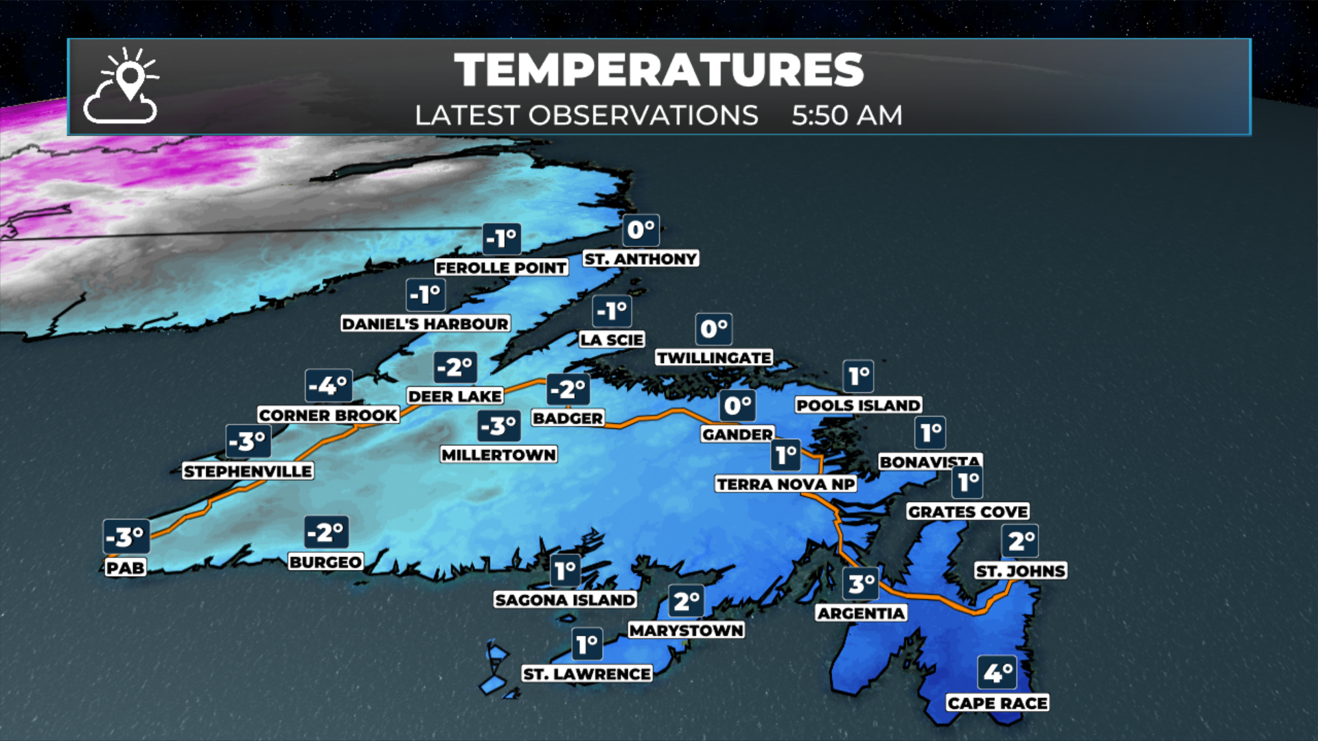
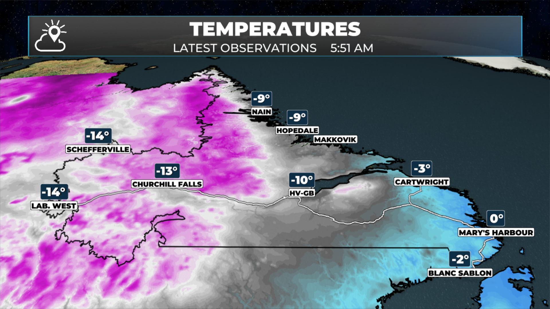
Much colder air has moved in overnight, bringing an abrupt end to yesterday's record-breaking warmth. Temperatures are hovering near freezing across much of the Island this morning, while the Big Land is dealing with readings well below zero. It's a dramatic turnaround from the 19°C we saw in St. John's just 24 hours ago — a temperature swing that perfectly captures the volatile nature of April weather in Newfoundland and Labrador.
If you woke up this morning wondering where yesterday's spring-like conditions went, this is your answer. The cold front that was over Labrador yesterday has moved through, and it's brought a completely different airmass with it. We are also seeing rain and showers over much of eastern Newfoundland this morning, so make sure you have the rain gear handy as you get set to head out the door! There is even some snow flying on the western end of the precipitation band this morning.
Radar Image from 6:15 AM NDT showing rain and frozen precipitation over eastern Newfoundland.
Tuesday: Rain Changes To Freezing Rain In The East
Today marks the beginning of a long-duration winter storm that will impact much of Newfoundland over the next several days. And when I say long-duration, I mean it — this isn't a quick-hitting system that moves through in 12 hours. This is a slow-moving, persistent system that's going to sit over us with winter weather well into Thursday.
For the Avalon Peninsula, the day starts with rain. Light rain at first, nothing particularly concerning. But as we move through the day, the cold air that moved in overnight is going to deepen and spread across the region. That's when things change a bit.
Later this afternoon and into this evening, that rain will change to freezing rain on the Avalon Peninsula. This is the start of what's shaping up to be a significant icing event — one that could have major impacts on travel, infrastructure, and daily life across the region.
The changeover won't happen all at once. We'll likely see a gradual transition, with some areas flipping to freezing rain earlier than others, depending on elevation and proximity to the coast. But by this evening, most of the Avalon should be dealing with freezing rain, and that's where things are going to stay for a while.
Tonight: Significant Icing Begins, Weather Alerts Issued
Freezing Rain Warnings and Special Weather Statements as of April 21, 2026 at 6 AM NDT
Significant freezing rain is likely over the Avalon Peninsula and northeast Newfoundland tonight into and through Wednesday. I’m not talking about a brief period of freezing rain that lasts a few hours — this will be prolonged event that could persist well into Wednesday or even Thursday.
Freezing rain is deceptive. It doesn't look particularly impressive when it's falling, but when that rain hits surfaces at or below freezing, it freezes on contact, building up a glaze of ice on everything it touches. Roads, sidewalks, trees, power lines — everything gets coated. The ligher the freezing rain, the more efficiently it will build up on trees and powerlines.
The Big Concerns for Tonight and Wednesday
Roads may become hazardous, particularly overnight tonight when we won't have the benefit of the sun helping to keep pavement temperatures above freezing. Even with road salt and treatment, ice accumulation can quickly overwhelm those efforts during a prolonged freezing rain event.
If you're on the Avalon Peninsula or the northeast coast, perhaps think about avoiding travel if at all possible tonight and into Wednesday morning. If you absolutely must travel, give yourself extra time, reduce your speed significantly, and understand that conditions can change rapidly.
The other major concern is the weight of ice building up on trees and power lines. Current guidance suggests ice accumulations in the 10 to 20 millimetre range are possible over the Avalon and northeast coast. Once you start getting into those numbers, the risk of widespread tree damage and power outages increases significantly.
Now is the time to prepare. Charge your devices. Make sure you have flashlights and batteries. If you have a generator, make sure it's ready to go. Know where your emergency supplies are. Hope for the best, but prepare for the possibility that the power could go out.
Freezing rain amounts between later today and 12 PM Thursday
What's Coming: A Preview
While the Avalon and northeast coast deal with ice, areas further west will see significant snow beginning Wednesday and continuing into Thursday. Central and parts of western Newfoundland are looking at widespread accumulations in the 20 to 30 cm range, with some areas potentially seeing more. The snow and ice will eventually make its way into Labrador as well.
I’ll have a full breakdown of the snow forecast in this afternoon’s update.
Snowfall forecast from later today through Thursday at 12 PM.
FIND ME ON SOCIAL!