
Thursday Morning’s Weather Briefing — July 30, 2026
Good Thursday Morning! Here are some highlights on the day(s) ahead:
Cool start this morning with temperatures in the teens for most areas.
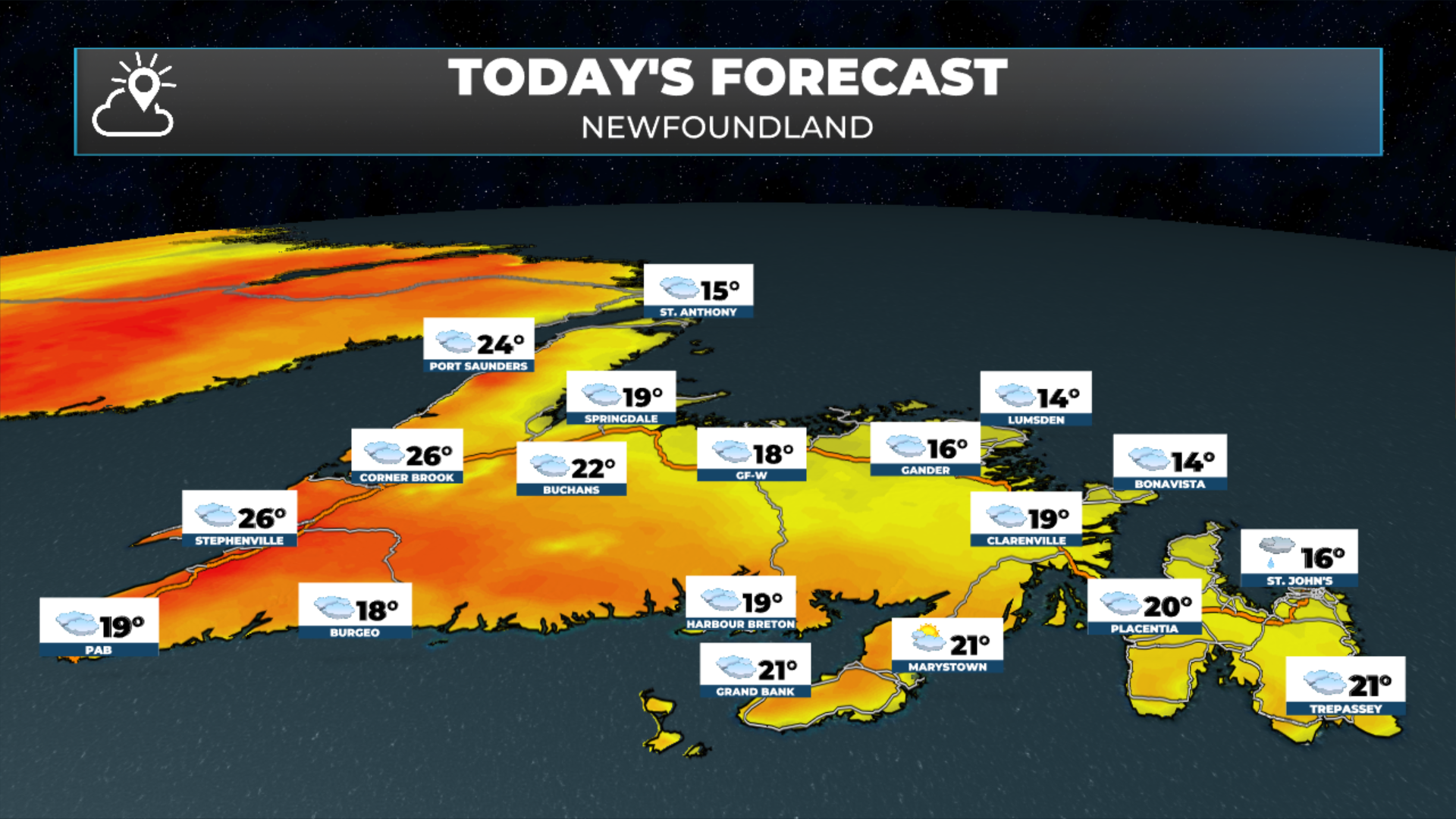
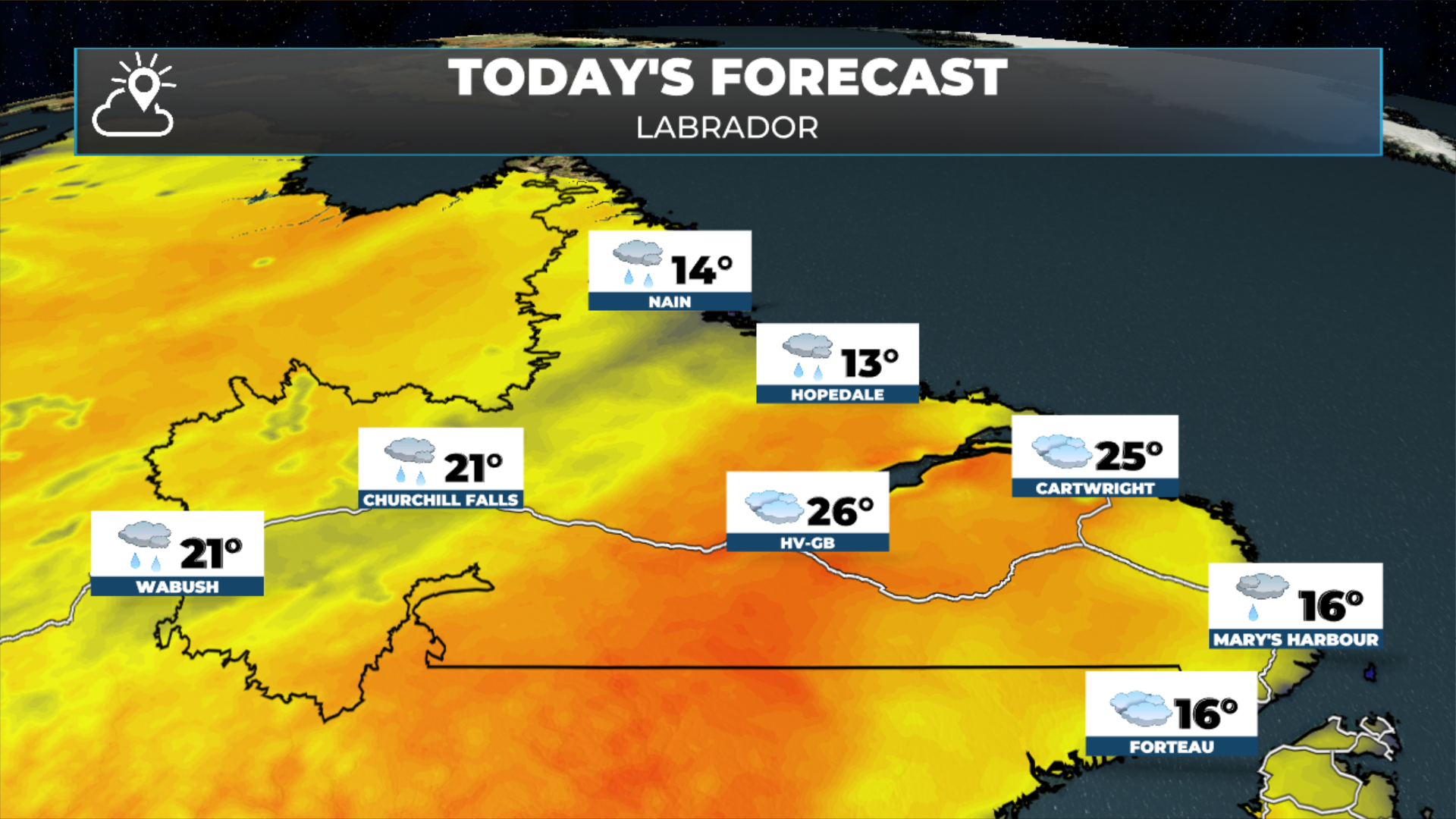
Daytime highs reach the teens to near 20 on the Island and the teens to the mid-20s in the Big Land.
Cloudy to mostly cloudy skies will be the rule, with a few isolated showers or afternoon thunderstorms in Labrador.
Another low moves in Friday, increasing moisture, shower and thunderstorm chances for much of NL.
This morning’s update is sponsored by Roebothan, McKay, Marshall.

Visit MakeTheCall.ca today to learn more about how the law firm can help you!
Temperatures as of 6:19 AM NDT on July 30, 2026.
Current conditions
Temperatures across Newfoundland this morning range from the lower to middle teens. Winds run from near 30 km/h across eastern and northeastern areas to near calm in the west and southwest. Those gusty winds will make it feel a touch cooler, even though it's quite humid out there once you factor in the relatively high dew point values for the temperatures.
In Labrador, temperatures sit in the single digits to lower teens along the coast, and the mid to upper teens from Happy Valley-Goose Bay back through Churchill Falls and Labrador City-Wabush. Winds there are generally light.
Precipitation and visibility
Not much on the go province-wide this morning, but skies are generally cloudy with a few pockets of drizzle on the island. Light drizzle is being reported in St. Anthony, St. John's, Wabush, and Gander. St. John's is down to 3 km of visibility, while Gander is reporting just 400 metres. Webcams also show there is quite a bit of fog across other areas of the Island this morning from the GNP to the West Coast. Visibility should improve over eastern and northeastern Newfoundland through the morning — though there are indications the fog rolls back in by Friday morning.
Today’s Outlook
Aside from those areas of drizzle and fog along and near the east and northeast-facing shores, there's not a whole lot happening across Newfoundland. That's a little different from what I expected yesterday — I thought today would be drier, but that may not entirely be the case for parts of the island. Expect generally cloudy skies across much of Newfoundland, with a few breaks of sun in the morning across the south and west. In Labrador, a few showers this morning become less widespread through the afternoon. Highs today land in the teens to lower twenties on the island, and the teens to the mid and even upper twenties in parts of Labrador — especially through Eagle River and the Goose Bay area.
Looking ahead
Our neighbours to the south in Nova Scotia are in for some rain today, heavy at times. It's already coming down in western Nova Scotia and works toward Halifax, and eventually PEI, through the day as an area of low pressure lifts north — reaching Cape Breton this evening.
That low then brings a significant amount of shower and rain activity to Newfoundland starting Friday afternoon, potentially continuing into Saturday, with the risk of showers and thunderstorms. Things should clear out by Sunday, which is looking decent at the moment.
My next update will be posted later today!
FIND ME ON SOCIAL!
