
Monday Morning’s Weather Briefing — September 14, 2026
Good Monday Morning! Here are today’s highlights
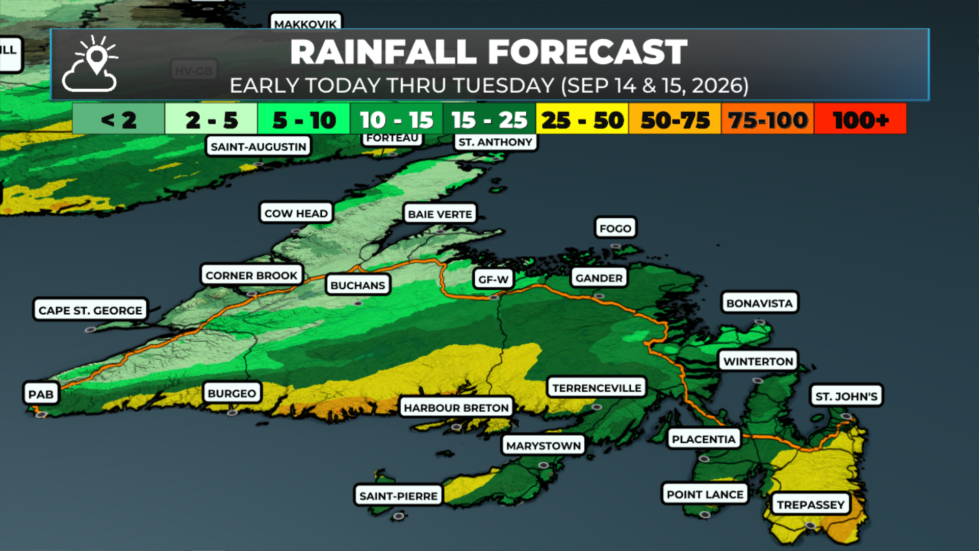
Rain will become widespread across the Island throughout the day — it’s already arrived on the West Coast.
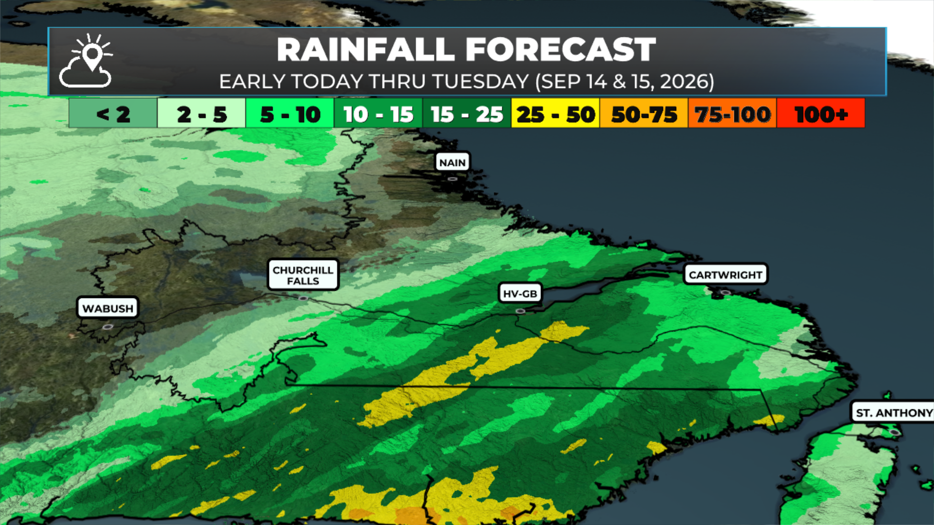
Rain will fall across much of Labrador throughout the day, especially in the southeast.
It will be breezy and humid today across much of NL as the air moving in has sub-tropical origins (think the Gulf Stream).
Fog will be found along and near south-facing shores.
Highs reach the upper teens to lower 20s across much of NL today
The rain ends overnight, and the weather improves on Tuesday.
More details below!
This morning’s update is sponsored by Roebothan, McKay, Marshall.

Visit MakeTheCall.ca today to learn more about how the law firm can help you!
We're waking up to plenty of cloud this morning, generally breezy conditions, and areas of rain already moving through southeastern Labrador and much of the West Coast, including the Great Northern Peninsula. Temperatures as of 5 a.m. are in the middle teens across the Island, with dew points just a touch cooler — so it's feeling a tad humid out there. Labrador is also in the teens at this hour, including 18º at HVGB.
What's Driving It
This morning's rain is tied to an area of low pressure developing near eastern side of Prince Edward Island and northwestern Cape Breton in Nova Scotia. As that low deepens through the day, the rain becomes more widespread across Newfoundland, arriving in Central and eastern areas by early to mid-afternoon. Rain and showers hang on through the day on the West Coast, the Northern Peninsula and in southeastern Labrador as the system moves through. It stays breezy today with winds out of the south and southwest, though not excessively strong. Gusts will be in the 40 to 60 km/h range.
Highs Today
It will be warm, especially for Central, northeastern, and eastern Newfoundland, where highs reach the upper teens to low twenties. It will also feel quite humid today as the air moving over the island originates from the Gulf Stream. This warm, humid air will drive fog along and near south-facing shores today (Newfoundland), and in those areas of onshore flow, temperatures will be in the lower to mid-teens.
Heavy Rainfall Potential
There's a risk of some heavy rainfall this afternoon and evening across southern and eastern Newfoundland, including the Burin, Bonavista, and Avalon Peninsulas. Southern parts of the outlined area, including most of the Burin peninsula, have a good chance of receiving more than 25 mm of rain this afternoon and evening. The chance of more than 50 mm is lower, but not zero. Farther north, the forecast is less clear, but I would expect a period of heavy rain. The question is, how long does it last? And will it coincide with drive time this evening? I’ll be keeping an eye on the radar today, but consider this a bit of a heads-up you probably wouldn’t find elsewhere.
This Evening, Overnight and Beyond
Rain and showers continue this evening before tapering off overnight and into Tuesday morning. Tuesday and Wednesday both look decent across the Island. Labrador sees some rain showers moving through during that stretch. Temperatures for the remainder of the week look near or above normal across most of Newfoundland. In Labrador, it turns cooler after Thursday — we'll have more on that as the week goes on.
FIND ME ON SOCIAL!
