
Monday Morning’s Weather Briefing — June 15, 2026
Good Monday morning! Here are today’s highlights:
It was a chilly night, and frost was observed at a few locations across the Island.
Today will see lots of sunshine over Newfoundland, while Labrador will see clouds in the east and rain in the west.
Highs reach the mid/upper teens on the Island and the eastern half of Labrador. The Northern and western parts of the Big Land will be cooler, with highs closer to 10ºC.
Showers and rain continue in Labrador through Tuesday, and arrive on the Island from southwest to northeast later Tuesday and Tuesday night
This morning’s update is sponsored by Roebothan, McKay, Marshall.

Visit MakeTheCall.ca today to learn more about how the law firm can help you!
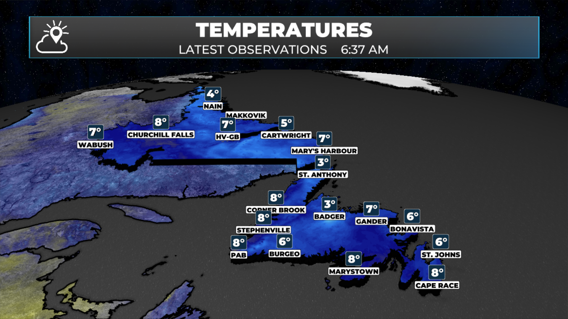
If you woke up to frost on the grass earlier this morning, you're not imagining it, some spots in eastern/central Newofundland did get close to the goose egg. A Frost Advisory was in effect much of the Island last night. Here's the silver lining, though: that same ridge of high pressure that gave us the chilly start is also setting up the best day we've seen in a while across a good chunk of the province. Sun and comfortable temperatures are the story for the Avalon and Central today. Just don't get too comfortable. A system moving into the Gulf of St. Lawrence ends the dry stretch tonight, and it's already arriving to the west.
Eastern Newfoundland and the Avalon get one more frosty start, especially away from town, but skies clear quickly and it's mostly sunny the rest of the day. Highs 14 to 16 with light winds… about as good as it gets this time of year.
Central is actually the warm spot on the Island today. Partly cloudy with highs 17 to 19 under that same ridge. Clouds build late in the day as the next system gets closer, but most of the day stays dry.
The West Coast is even milder, with highs between 18 and 21 degrees. The warmest temperatures are in the Humber Valley and around the Bay of Islands, while it's a bit cooler over the Long Range highlands. Cloud cover increases throughout the afternoon, signaling what's ahead. Showers are expected to arrive by tonight, with about a 25 percent chance, as the approaching system makes its way in.
On the South Coast, expect highs of 10 to 12 degrees under mostly cloudy skies. Today is cooler than the West Coast, and both wind and shower chances will rise by tonight as the system moves closer from the west.
Near Port aux Basques and the Wreckhouse, temperatures are similar at 10 to 12 degrees, but wind is the main story. Southeast winds will build to 25 to 40 km/h during the day and increase to 30 to 50 km/h at night as the pressure gradient tightens. Rain chances will rise above 50 percent overnight.
The Great Northern Peninsula and the Straits will be the slowest to warm up today, with highs only between 8 and 10 degrees under cloudy skies. This area will also see shower chances increase first, starting in the evening. Expect a 20 to 25 percent chance during the day, rising higher overnight as the leading edge of the system arrives.
In Labrador, conditions vary depending on location. Labrador West is expecting a wet day, with rain on and off and highs between 9 and 11 degrees, as the system's front passes through. Central Labrador around Happy Valley-Goose Bay will be milder, with temperatures from 17 to 19 degrees and a breezy northeast wind. Showers are likely this afternoon and will become widespread overnight. Up the North Coast at Nain, it's cooler, with highs only between 6 and 8 degrees, and a few showers in the morning with a higher chance of more showers tonight.
Looking ahead, the high-pressure ridge will weaken tonight, leading to more unsettled weather on Tuesday. The western part of the island and Labrador can expect lingering showers. Just across the Strait of Belle Isle, Quebec's Lower North Shore, including Minganie and Anticosti, will see a significant rainfall of 50 to 70 mm through Tuesday, highlighting how much moisture this system is carrying. After Tuesday, the pattern looks to stay fairly active across the east through the rest of the week, so we'll keep an eye on what’s coming next.
My next update will be posted later today!
FIND ME ON SOCIAL!