
Pattern Shift Brings A Return Of RDF This Week

This forecast is sponsored by Atlantic Edge Credit Union. Visit aecu.ca or drop by one of their 16 branches across the province to experience banking that feels like home.
What’s Happening
Satellite imagery this afternoon shows increasing cloud cover across parts of the Avalon Peninsula and other eastern sections of Newfoundland and Labrador — though not everywhere just yet. Even fog has crept it’s way into the East End of St. John’s! The culprit is a low pressure system offshore, drifting south. Areas well inland and away from coastal Labrador — like the Northern Peninsula, central and eastern Newfoundland — enjoyed sunshine today, but that’s about to fade or has already.
The Setup: A Blocked Atlantic
Interestingly, this pattern ties back to an area of low pressure over the U.K. and Western Europe. That system is acting like a traffic cop, backing up the entire weather flow across the North Atlantic. A strong ridge of high pressure in between is holding firm — and that’s causing multiple North Atlantic lows to stall out to our south, east, and north.
For us, that means an onshore, damp, and cloudy flow — lots of RDF (rain, drizzle, and fog) ahead.

What to Expect
Future radar and cloud model data show increasing clouds overnight and into Wednesday, with showers becoming more frequent along coastal Labrador. As we move into Thursday and Friday, waves of moisture will bring persistent rain to Labrador and periods of drizzle and fog for northern and eastern Newfoundland.
This setup will likely linger into the weekend — so don’t expect much sunshine for a while.
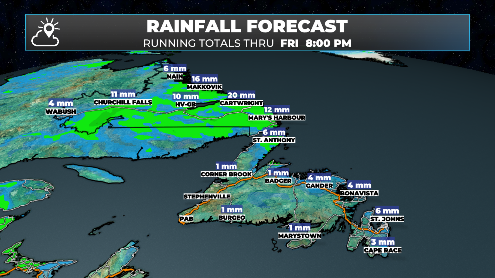
Rainfall Outlook
Unfortunately, while the pattern looks damp, it’s not especially wet for everyone. Coastal Labrador may see some decent rainfall totals, but much of the Island — including St. John’s — might struggle to reach even 6 mm through Friday evening.
That’s disappointing news for areas desperate for meaningful rain — especially with low water levels at Beothuk Lake and Deer Lake. Central and eastern regions need it badly, but the atmosphere isn’t delivering much just yet.
Temperature Trends
If nothing else, this pattern will even out our temperatures. St. John’s and the northeast Avalon will see daytime highs varying by only about 2 °C all the way into next week — an impressive stretch of uniform conditions.
Tonight’s lows will range from 1 °C to 6 °C in Labrador and 3 °C to 6 °C across the Island — a good night to stay in and follow election results. Tomorrow’s highs will be 8 °C to 14 °C, coolest in the northeast, warmest along the south and southwest coasts.
Those southern areas — especially around Port aux Basques and the Codroy Valley — will fare best under this setup, with relatively brighter, milder weather while most of us remain under clouds and drizzle.
The Week Ahead
For eastern, central, and western Newfoundland — as well as Labrador — it’s the same song and dance for the next several days:
Mostly cloudy skies
Cool, steady temperatures
Occasional drizzle or fog
A few brief sunny breaks possible by the weekend, mainly inland Labrador
Overall, a stubborn, dull weather pattern that will likely persist into early next week.
📱 Get the Sheerr Weather App in the Apple App Store and Google Play Store.
🗺️ Check out the Map Room to see all the latest weather observations for the Province.
🎥 Check out the Provincial Highway Cams to see 👀 what’s going on around our highways and byways!