
Christmas Eve Weather Update — December 24, 2025
Temperatures as of 7 AM this morning!
Good Wednesday morning!
For many areas, it certainly is a cold start this morning!
The weather across the Province will be on the quiet side today, with an abundance of sunshine in most areas. Highs will be in the minus single digits on the Island and minus teens in Labrador. Wind speeds will be light to moderate, almost across the board.
Today’s forecast | December 24, 2025
Now that being said… There is one trouble spot today, which looks to be from near the Bay of Exploits to the Bonavista Peninsula area. This region of Newfoundland will see periods of light to moderate snowfall throughout much of the day, thanks to a little weather disturbance (trough) in the area that wants to go nowhere fast. The little animation below shows this quite well.
Snowfall in this arae today will be roughly 5 to 10 cm, with locally higher amounts possible. Especially inland and in the higher terrain facing north.

This update is sponsored by Roebothan, McKay, Marshall.
Visit MakeTheCall.ca TODAY to learn more about what the law firm can do for you.
Tap on each image to see a larger version.
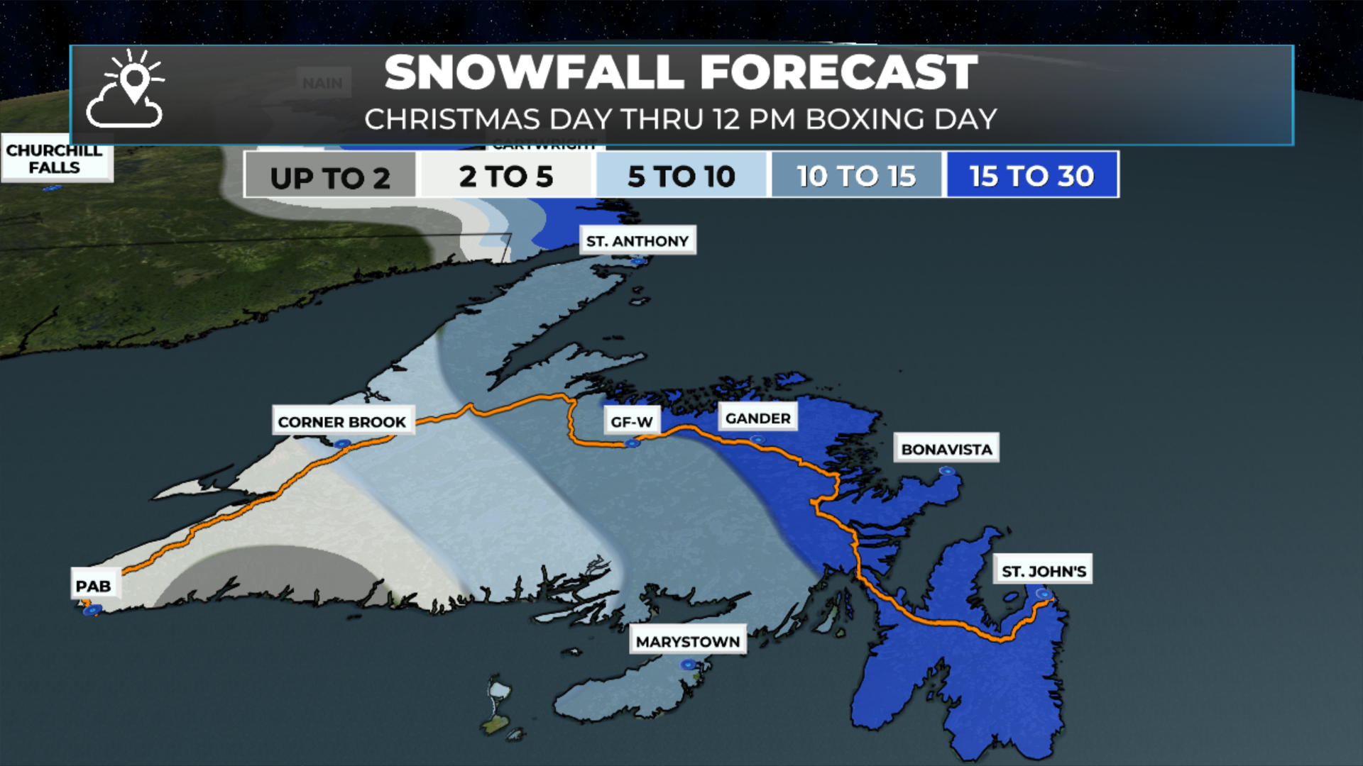
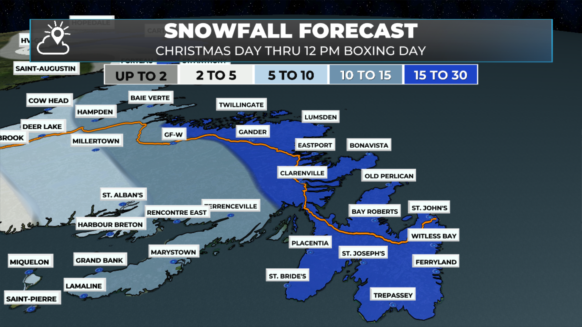
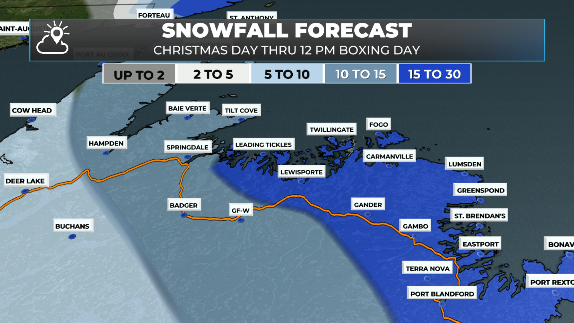
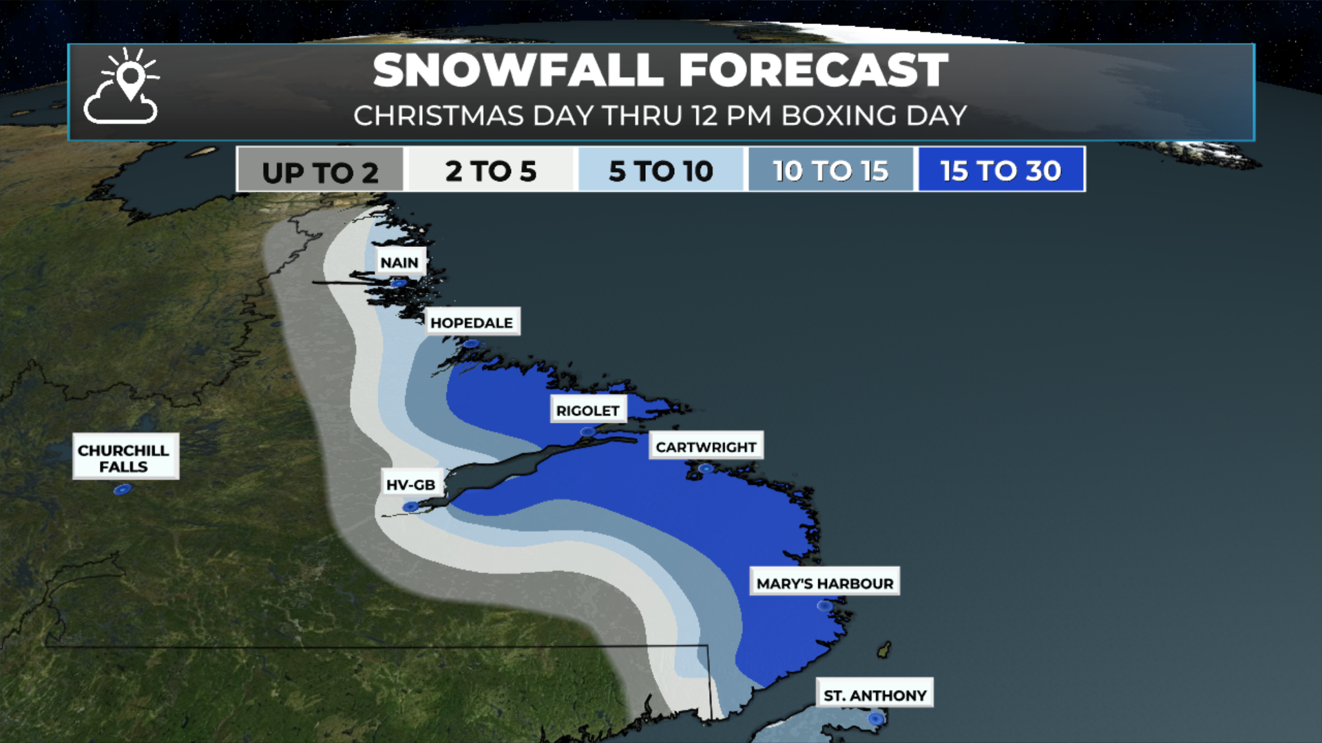
The next order of business is the storm moving in for Christmas Day into Boxing Day. There is still some uncertainty regarding track and snowfall amount, especially on the Avalon. Outside of that, it’s a pretty straightforward forecast. I’ll have an in-depth update this afternoon!
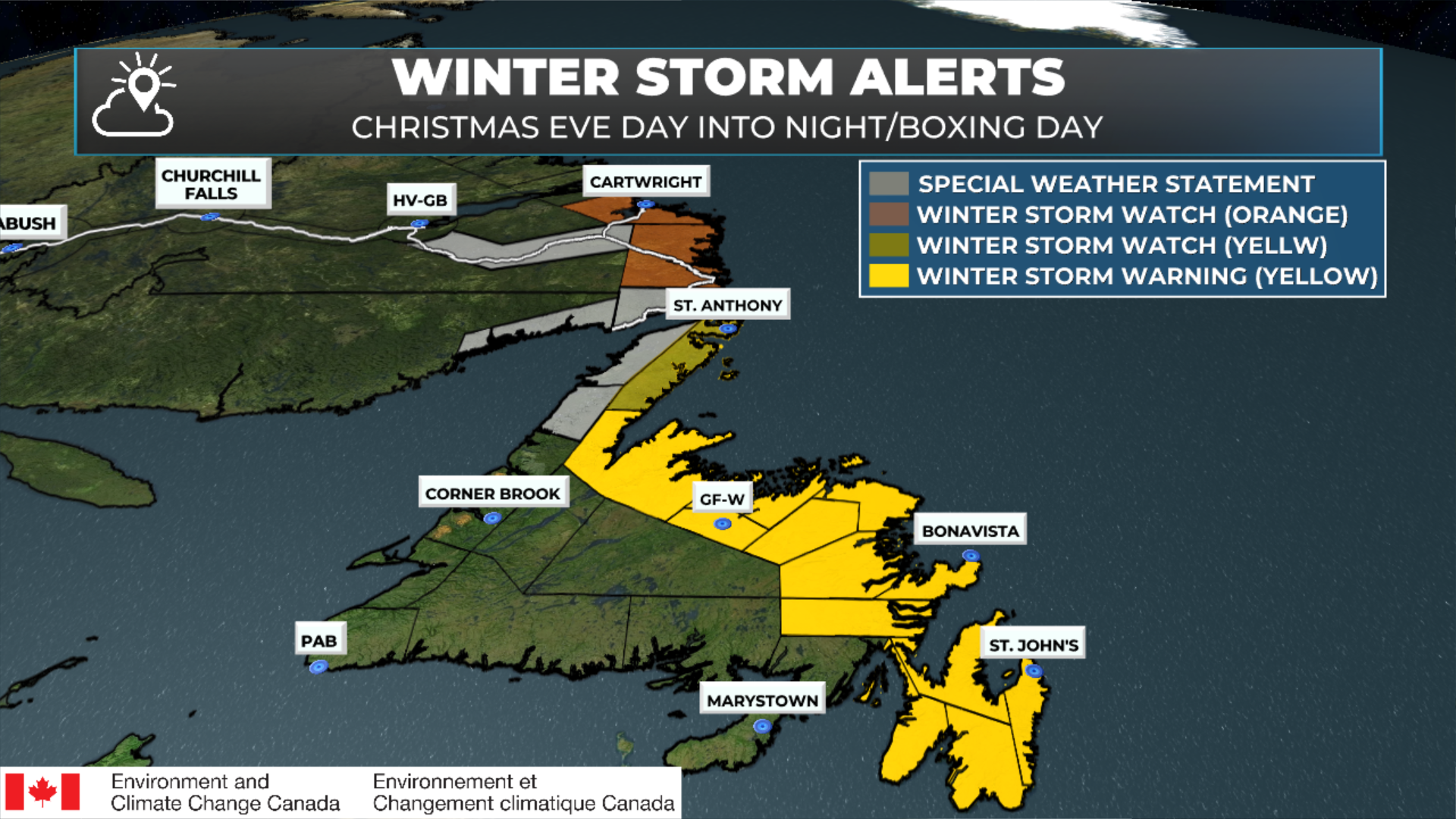
Several weather alerts have been issued by ECCC NL ahead of the incoming snow and wind, including Winter Storm Watches and Warnings, a Blowing Snow Advisory, and Special Weather Statements for various areas of NL. In terms of timing, snow will arrive late tonight or very early tomorrow morning in the southeast, then spread northwest and west throughout the day, reaching the GNP and parts of Labrador by evening or tomorrow night. The snow and wind will ease for most areas by Boxing Day morning, with the exception of the coast of Labrador, where it will continue through the day. The alerts are as follows (also keep in mind the amounts forecast by EC may differ from my forecast — in this case the amounts are quite similar).
Winter Storm Warnings are in effect across a large portion of Newfoundland for Christmas Day, issued by Environment Canada, with high forecast confidence. Heavy snowfall, blowing snow, and strong winds will combine to create hazardous travel conditions, especially during the day Thursday and into Thursday night. Snowfall totals will generally range from 10 to 35 cm, with locally higher amounts possible, while wind gusts may reach 80 to 110 km/h, strongest along exposed coastal areas. Visibility will be significantly reduced at times in blowing snow, and travel is likely to be difficult. Conditions should gradually improve late Thursday night into early Friday for most areas, though another similar system remains possible Friday night into Saturday, which could further impact holiday travel plans.
Also keep in mind a SECOND system will move in during the afternoon on Boxing Day (southern/eastern Newfoundland first) and will bring more heavy snowfall and possibly rainfall to the same areas. Details on this forthcoming later today.
Central and Northeastern Newfoundland (All Snow / Blowing Snow)
Snow and blowing snow will dominate throughout the event, with the longest-lasting and most severe conditions expected along the coast and in parts of central Newfoundland.
Locations:
Bay of Exploits
Bonavista North
Bonavista Peninsula
Clarenville and vicinity
Gander and vicinity
Terra Nova
Grand Falls-Windsor and vicinity
Green Bay – White Bay
Expected impacts:
Snowfall: 10 to 35 cm, locally higher
Winds: Northeasterly 70–100 km/h, shifting west to northwesterly 80–110 km/h Thursday night
Blowing snow and poor visibility, especially coastal and overnight for central areas
Avalon Peninsula (Snow Changing to Rain in Some Areas)
The Avalon will see several hours of heavy snow and blowing snow, but milder air is expected to push in Thursday afternoon, causing a changeover to rain or drizzle in many areas. Parts of the western Avalon may remain snow for most or all of the day.
Locations:
Avalon Peninsula North
Avalon Peninsula Southeast
St. John’s and vicinity
Avalon Peninsula Southwest
Expected impacts:
Snowfall: 15 to 25 cm, locally higher before any changeover
Winds: Northeasterly 80–100 km/h, shifting northwesterly near 80 km/h
Reduced visibility during snow and blowing snow before precipitation transitions
Travel is expected to be challenging across all warned regions. Consider postponing non-essential travel and outdoor activities until conditions improve.
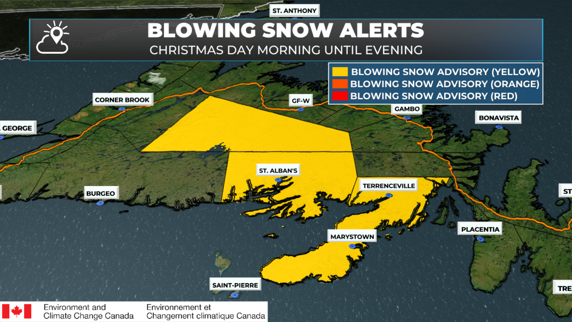
A Blowing Snow Advisory is in effect for parts of southern and central Newfoundland, issued by Environment Canada, with high forecast confidence. Fresh snowfall combined with strong winds will lead to reduced visibility in blowing snow, particularly on exposed highways and open areas. Snowfall amounts of 10 to 15 cm are expected, with locally higher totals possible on the Burin Peninsula. Northerly to northeasterly winds gusting 60–80 km/h will shift northwesterly later Thursday, keeping travel conditions challenging through the day before gradually improving Thursday evening. Motorists are advised to consider adjusting travel plans where possible, especially with another potential system later Friday into Saturday.
Areas under the Blowing Snow Advisory:
Burin Peninsula
Connaigre
Buchans and the interior (including the Bay d’Espoir Highway area)
A Winter Storm Watch is in effect for Christmas Day into early Boxing Day for parts of northern Newfoundland, issued by Environment Canada, with high forecast confidence. A developing winter storm is expected to bring heavy snowfall and widespread blowing snow, particularly Thursday night when conditions are forecast to be at their worst. Snowfall totals of 15 to 25 cm are possible, along with strong north to northwesterly winds gusting 80 to 110 km/h, leading to very poor visibility and difficult travel. Conditions should gradually improve Friday morning as winds ease, but travel disruptions are likely during the height of the storm. Another potential system late Friday into Saturday remains uncertain and should be monitored closely.
Area under the Winter Storm Watch:
Northern Peninsula East
A Special Weather Statement remains in effect for parts of the western Great Northern Peninsula, issued by Environment Canada, as a winter storm is expected to impact the area from late Christmas Day into early Boxing Day. Snowfall amounts of 5 to 15 cm are forecast, accompanied by strong, shifting winds that will lead to widespread blowing snow, especially overnight Thursday night when conditions are expected to be at their worst. Northeasterly winds gusting 70 to 80 km/h will shift to northwesterly 80 to 110 km/h Thursday night before easing Friday morning. Travel may be affected, particularly during the overnight period. Another potential system late Friday into Saturday remains uncertain and should be monitored closely.
Areas under the Special Weather Statement:
Parsons Pond – Hawke’s Bay
Port Saunders and the Straits
An Orange Level Winter Storm Watch has been issued for parts of southeastern Labrador, signaling the potential for high-impact winter conditions from Christmas Night into Boxing Day, according to Environment Canada. This system has the potential to be severe, with heavy snowfall and very strong winds combining to produce widespread blowing snow and near-zero visibility at times. Snowfall totals of 30 to 50 cm are possible, along with northwesterly wind gusts of 100 to 120 km/h, making travel extremely difficult or potentially impossible in exposed areas. Conditions are expected to persist from Thursday evening through Friday afternoon before gradually improving. A second system remains possible late Friday into Saturday and should be monitored closely.
Areas under the Orange Level Winter Storm Watch:
Norman Bay to Lodge Bay
Cartwright to Black Tickle
An evolving winter storm setup is in place across southeastern Labrador for Christmas Night into Boxing Day, according to Environment Canada. While the earlier Orange Level Winter Storm Watch has ended for parts of the region, hazardous winter conditions remain likely, with snow, strong winds, and blowing snow expected to affect travel. Areas farther east and north are now under Special Weather Statements, while the potential remains for very poor visibility, especially in exposed locations. Snowfall amounts will vary significantly by location, ranging from 5 to 15 cm in some areas to locally much higher totals previously highlighted farther south, combined with wind gusts of 80 to 110 km/h. Travel may be difficult at times from Thursday evening through Friday afternoon, and another system remains possible late Friday into Saturday.
Southeastern Labrador – Ongoing Winter Impacts
Special Weather Statement areas (snow & blowing snow):
Red Bay to L’Anse-au-Clair
Eagle River
Expected impacts:
Snowfall: 5 to 15 cm
Winds: Northeasterly to northwesterly 80–110 km/h
Blowing snow, worst in exposed areas
Travel may be affected Thursday evening through Friday afternoon
Thursday, Friday, and even Saturday will not be. Weather Alerts are already in effect for part of that time frame. I’ll have more details on the Holiday forecast this afternoon.
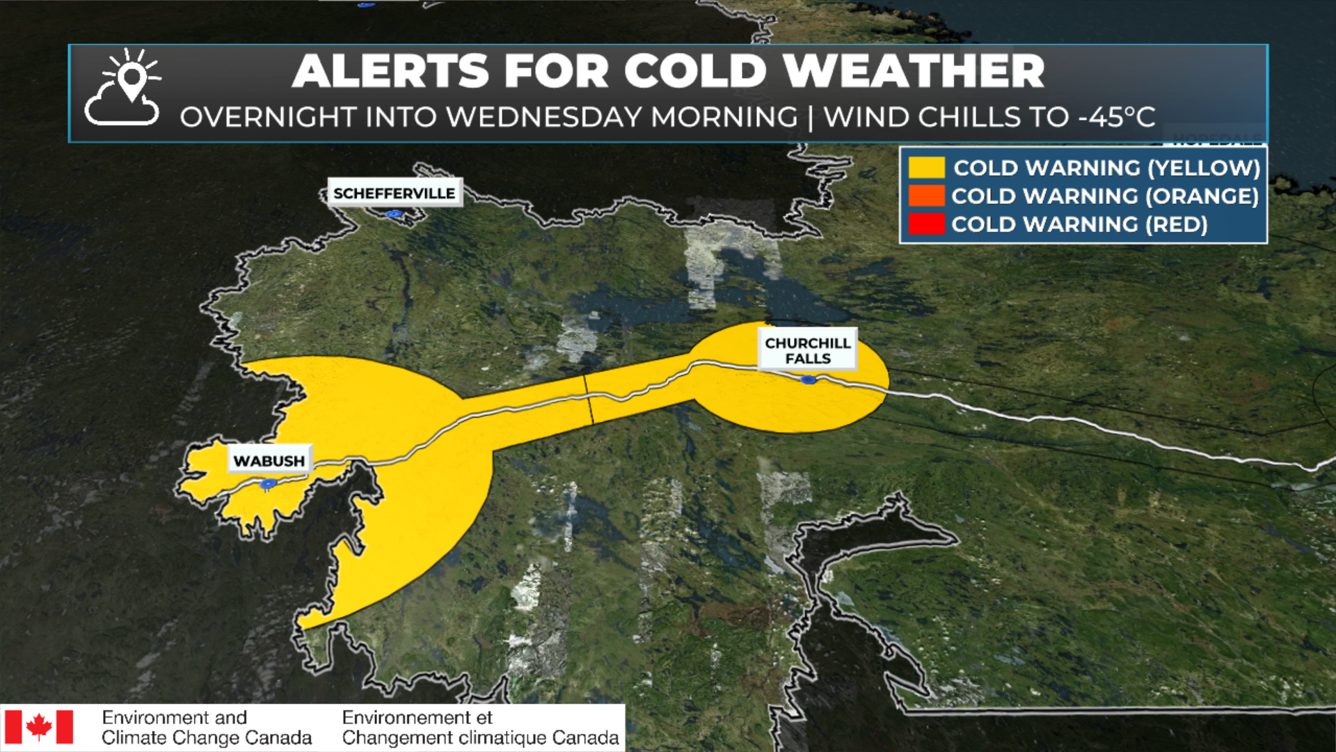
A Cold Warning is in effect for western Labrador, issued by Environment Canada, with high forecast confidence. A period of dangerously cold wind chills is expected overnight tonight into Wednesday morning, with values falling to –40 to –45, creating a heightened risk of frostbite and hypothermia in a short period of time. Anyone spending time outdoors is at risk, with increased concern for young children, older adults, those with chronic illnesses, and people working or exercising outside. Extra precautions should be taken to limit exposure and ensure adequate shelter.
Areas under the Cold Warning:
Churchill Falls and vicinity
Labrador City and Wabush
Residents are advised to dress in warm layers, use a wind-resistant outer layer, and reduce time outdoors where possible until conditions improve.
I’ll have my next update posted later today, where I’ll get into more details on tonight, tomorrow, and the SECOND system arriving later on Boxing Day into Saturday… which promises to bring another round of heavy snowfall to much of the same area.
📱 Get the Sheerr Weather App in the Apple App Store and Google Play Store.
🗺️ Check out the Map Room to see all the latest weather observations for the Province.
🎥 Check out the Provincial Highway Cams to see 👀 what’s going on around our highways and