
Wednesday Morning’s Weather Briefing — February 11, 2026
Temperatures as of 6:37 AM NST (6:07 AM AST) - February 11, 2026.
Good Wednesday Morning!
Here are today’s weather highlights:
Areas of drizzle and freezing drizzle will be found from the coast of Labrador to the Avalon Peninsula of Newfoundland. Freezing Drizzle Advisories (Yellow Level) have been issued by Environment Canada.
Outside the freezing drizzle, expect generally cloudy skies today with quieter weather. The exception is southeast Newfoundland, where there will be sunshine today.
Highs will be near 0ºC for much of the Island and coastal Labrador, while areas west of Happy Valley - Goose Bay in Labrador will be closer to the minus teens.
The next low arrives tomorrow and will bring some snow to much of Newfoundland and parts of Labrador. Western Newfoundland and Labrador’s coast will see the snow continue into Friday. Other areas will see it end Thursday afternoon or evening. For most areas, snowfall with this system will not be significant.
Newfoundland and Labrador Synopsis
The weather pattern we have been in for the last few days will generally remain in place today. Expect cloudy skies over much of the Island in northerly or northeasterly flow. This will bring some sunshine to the southwest corner of the Island today, and that will pretty much be the only area that sees it. Locations along and near north or northeast-facing shorelines from the Northern Peninsula to the Avalon Peninsula and St. John’s Metro area will see drizzle and freezing drizzle today, as outlined above via the Freezing Drizzle Advisories that are currently in effect. Highs today will be near 0ºC for much of the Island, and wind speeds will be lower than they were yesterday. In fact, they should be dropping through the day for most areas.
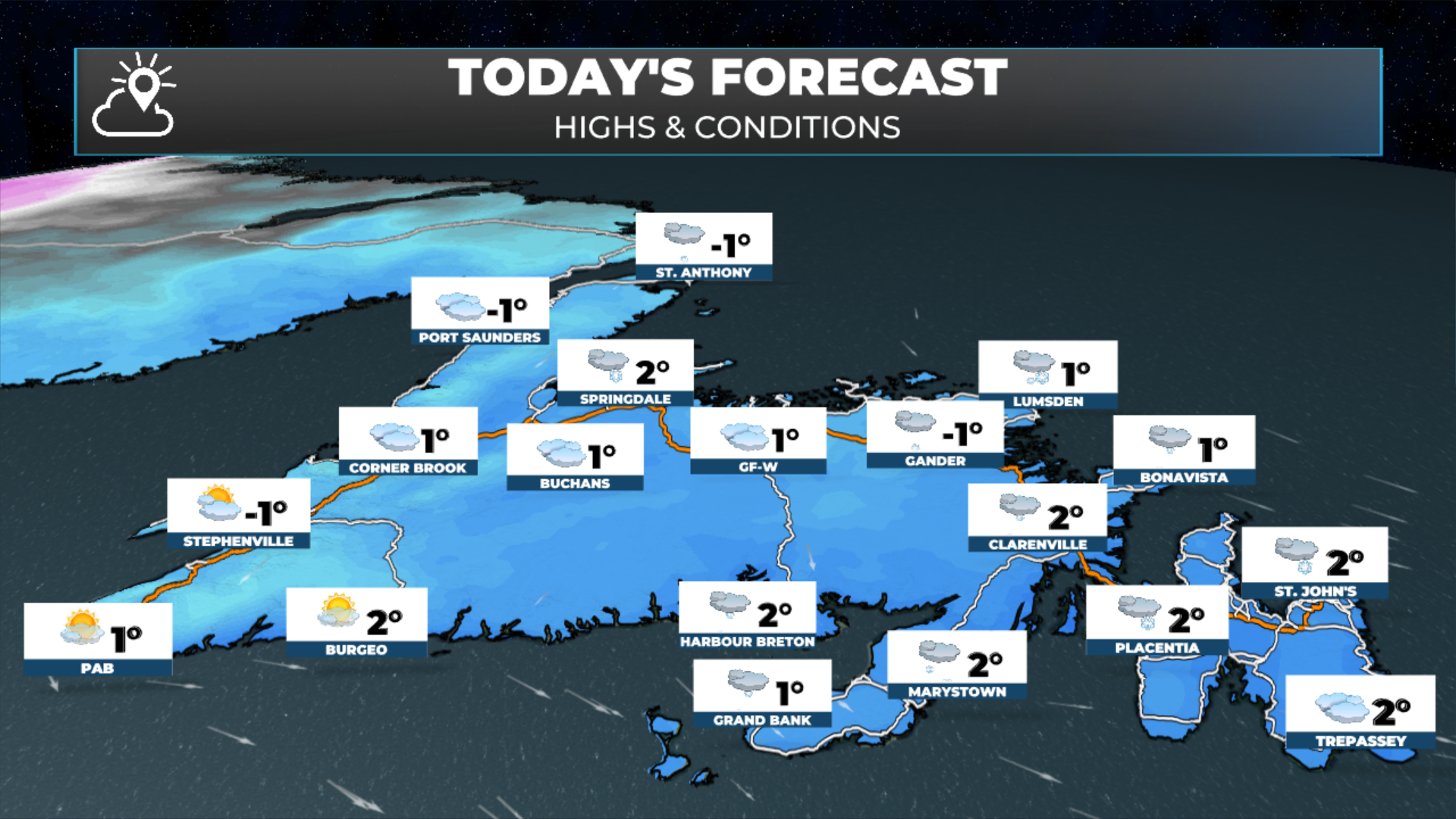
Newfoundland’s forecast for today - February 11, 2026.
The same will be true for much of Labrador today… We can expect freezing drizzle along parts of the coast and/or flurries, while areas inland will be cloudy with some sunny breaks and cooler. Highs along the coast will be near freezing, while western areas will be near the minus teens.
Labrador’s forecast for today - February 11, 2026
The next weather-maker moves in tomorrow, bringing a period of snow across the Island. It will start near or pre-dawn in the south and a bit later elsewhere. For areas away from the west coast and northern peninsula, the snow will be done by about noon. And unlike what you may have seen yesterday on the socials (not from me), this will NOT be a significant snowfall for the majority of the Island. Here are what snowfall totals currently look like by Thursday evening:
Eastern Newfoundland / Avalon Peninsula: 2 to 5 cm (locally up to 10 cm)
South Coast and Burin Peninsula: 5 to 10 cm
Central and northeastest Newfoundland: 5 to 10 cm (locally up to 15 cm)
Western Newfoundland: 5 to 10 cm (less on the West Coast north of Lark Harbour)
Northern Peninsula: 5 to 10 cm (up to 15 cm in the higher terrain)
Labrador: 5 to 10 cm
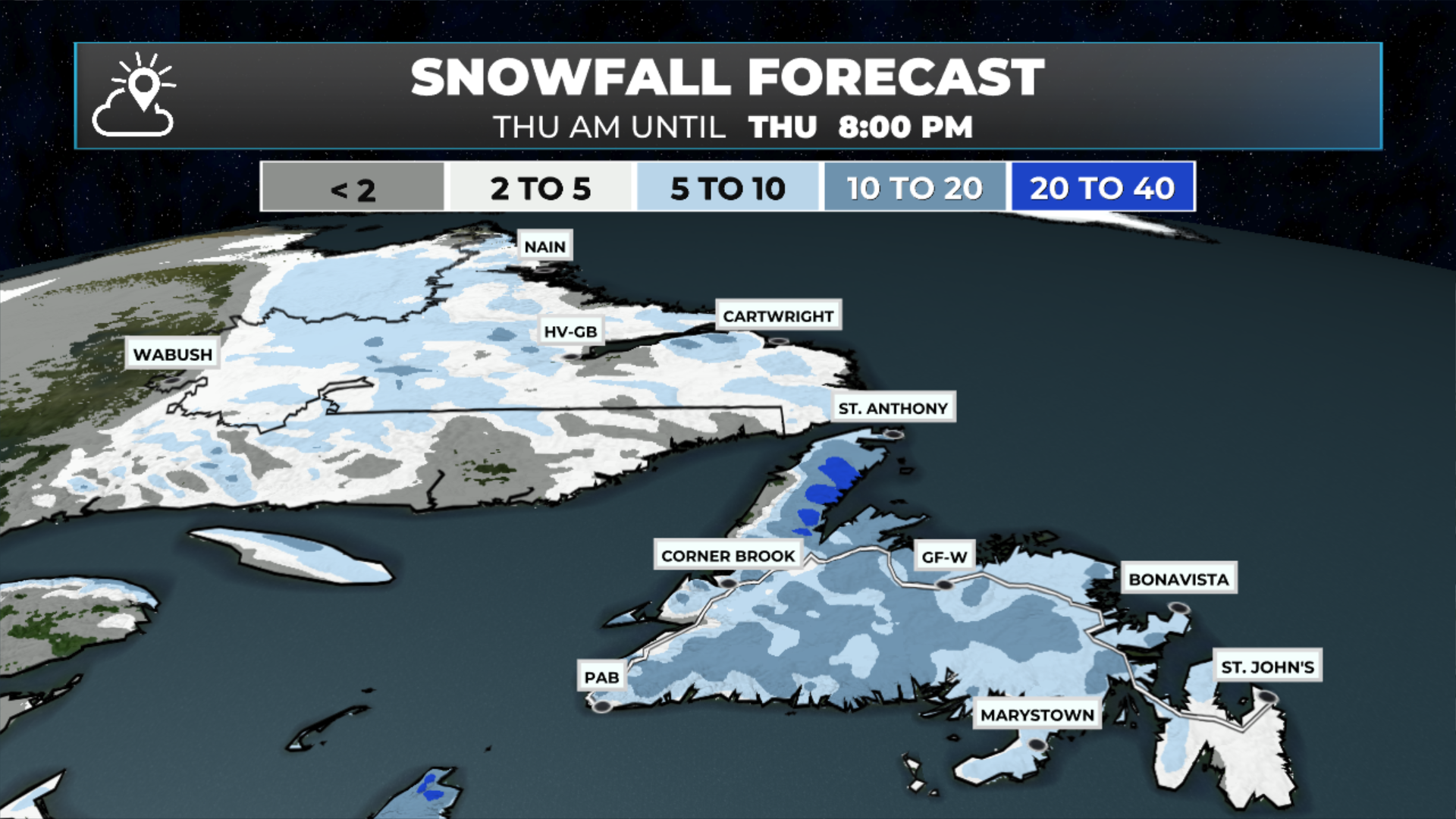
Snowfall forecast from Thursday morning until Thursday evening (Feb 12, 2026)
Now… areas of western Newfoundland and parts of Labrador will the snow continue into Friday and this IS WHERE snowfall totals will be significant by the time friday evening rolls around. Snowfall amounts along the West Coast and the higher terrain of the Northern Peninsula (eastern side) will be over 20 cm. The coast of Labrador will be the same. It also look slike a nearly stationary band of heavy snow may set up shop between Churchill Falls and Labrador City. Areas under this band will see heavy snowfall; however, it’s narrow, and I’ll have to watch the charts closely to see where this actually sets up shop tomorrow.
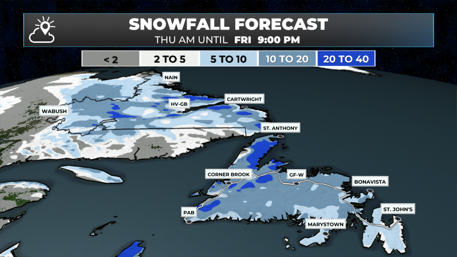
Snowfall forecast from Thursday morning until Friday evening (Feb 12 - 13, 2026)
The snowfall maps above show the change in amounts from Thursday evening to Friday evening and should give you a good indication of where the most snow will fall.
The weather for the weekend currently looks quiet.
FIND ME ON SOCIAL!