
Tuesday Morning Update — January 20, 2026
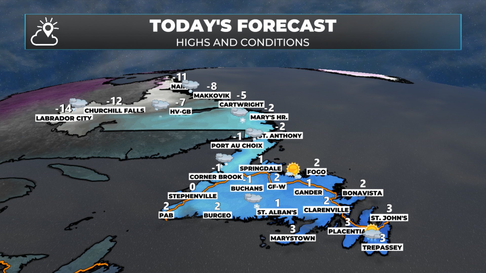
Today's forecast (January 20, 2026)
Good Tuesday Morning!
Here are today’s weather highlights:
The Northern Lights were stunning last night (I’ll have a gallery posted later today)!
A weak area of low pressure will move across the Province today, bringing light snow and flurries to Labrador, and flurries and pockets of light snow to most of Newfoundland. There will be some areas of moderate snow over the West Coast and Northern Peninsula, which will make conditions locally stormy.
Flurries will mix with rain showers in the east and on the Avalon.
Colder air moves in tonight, and snow squalls take hold over western and southern Newfoundland
Snow Squall Watches are in effect for both areas
Extreme Cold Warnings are in effect from the Churchill Valley to Labrador City and Wabush for tomorrow morning, as wind chills will be as low as -45º to -50º

This update is sponsored by Roebothan, McKay, Marshall.
Visit MakeTheCall.ca TODAY to learn more about what the law firm can do for you.
The Northern Lights over Middle Cove last night (January 19, 2026). Credit: Sheerr Weather
The Northern Lights put on quite the show over North America last night, as a very intense geomagnetic storm interacted with our planet’s atmosphere. These displays occur when charged particles from the sun are directed at Earth. Last night was an exceptional event, and I’ve put together a gallery of images I received via social media and app uploads!
Today’s Forecast
The weather across the Province today will be calmer than yesterday, but not exactly calm. A weak area of low pressure will move across the region. This will bring widespread flurries and light snow to Labrador and most of Newfoundland. In the east, expect a mix of rain showers and flurries today. The Southwest Coast, West Coast and Northern Peninsula will see pockets of moderate snow and locally stormy conditions at times today as this little nuisance low swings through.
Reminder: Use the live radar in the app to track snow flurries in your area today!
The animation (below) shows how the snow and rain will play out across the Province throughout the day.
Extreme Cold and Snow Squalls
As weak as this low is, it’s essentially the leading edge of some very cold air that will arrive overnight. A Yellow Level Extreme Cold Warning is in effect from the Churchill Valley to Labrador City and Wabush for wind chills as low as -45º to -50º tomorrow morning.
Yellow Level Extreme Cold Warning in effect for parts of Labrador via ECCC NL.
At the same time, that cold air will move over the Gulf and the coastal waters around Newfoundland, the result of the temperature difference between the ocean and the air will generate areas of intense snow squalls over western and southern Newfoundland. Yellow Level Snow Squall Watches go into effect for these areas tonight and will extend through Wednesday and possibly Wednesday night.
Yellow Level Snow Squall Watches are in effect from later tonight through Wednesday, via ECCC NL.
While these will occur over many areas, areas around Corner Brook, Bay St. George, the Burin Peninsula and the southern Avalon may see long-lived squalls, leading to significant snowfall over relatively narrow swaths. The alert states that most locations will see 5 to 10 cm, but some will see WAY more.
Remember that snow squalls are short-lived but intense bursts of heavy snow, often accompanied by strong gusty winds. They can cause sudden white-out conditions and rapidly icy roads, making travel dangerous even though they usually last only minutes to an hour. In some cases, they can last longer than an hour. Significant snowfall is possible under these narrow bands of snow.
Outside of the snow squalls, expect cooler and breezy conditions on Wednesday under a mix of sun and cloud.
Wednesday’s Forecast - January 21, 2026.
Thursday’s Forecast
The weather on Thursday will start quieter across the Province, with less snow squall activity. That being said, another low will roll in during the afternoon and will spread snow across Newfoundland during the second half of the day. This will arrive in the east in the evening. Snow will end in most areas by Friday morning, although in the east, the snow will end as some rain or drizzle (because why not?). And right now, other than flurries, the weather on Friday looks as calm as we have seen in a while.
Snow arriving Thursday afternoon (January 22, 2026)
Another shot of cold air looms for the weekend as our weather pattern shifts to a colder one. I’ll explain more on this in my next forecast later today.