
Friday Morning’s Weather Update — March 13, 2026
Good Friday Morning!
Here are today’s weather highlights:
It’s very warm in the east with areas of heavy rain, it’s snowing or close to snowing on the West Coast/GNP and in southeast Labrador. Central is currently between!
A cold front moves through today, and the forecast is somewhat complex. Details below!
Many schools are closed or closed for the morning. Find a live-updating list in the Storm Centre!
Today’s Forecast for Newfoundland & Labrador
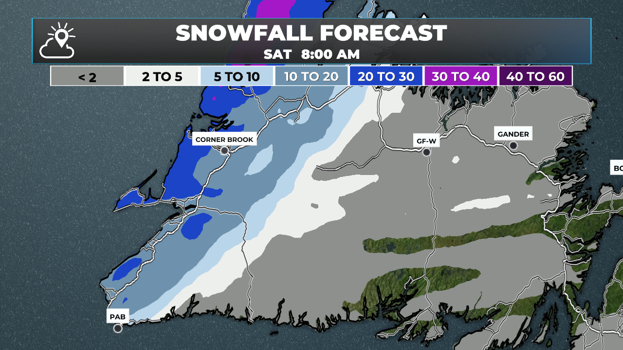
A cold front will move across the Island today from west to east. As of early this morning, that cold air is located near the West Coast. Near and behind the front, temperatures are near 0ºC, with rain, freezing rain, or snow falling. As the front moves eastward, more of western Newfoundland will see any liquid precipitation change to snow this morning. Travel conditions through much of western Newfoundland will be less than ideal today.
Meanwhile, areas of central and eastern Newfoundland will see much warmer air persist for a while longer. In central Newfoundland, this morning’s rain will change to snow by midday, and travel conditions will similarly deteriorate. If you’re driving from eastern to western Newfoundland today, the transition from rain to snow can occur extremely quickly — be prepared for a significant change in weather over a very short distance. In the east, the warmer conditions will remain until late afternoon, when temperatures will fall sharply with the passage of the front. That cooling will occur a few hours earlier in central Newfoundland, as the front will reach that area sooner.
We will also see rain at times today, becoming steadier through the morning and afternoon. All areas will see the rain and snow end this evening as the cold front moves offshore.
The animation below shows how temperatures will play out through the day.
Today and tonight will also be windy across much of the Island. The strongest winds will be on the Avalon Peninsula this morning, then expand westward later today and into tonight. On the Avalon, winds will peak this afternoon before slowly subsiding this evening. Areas to the west will see wind speeds increase this afternoon and continue into tonight, easing by Saturday morning. The animation below shows how the winds will play out through the day.
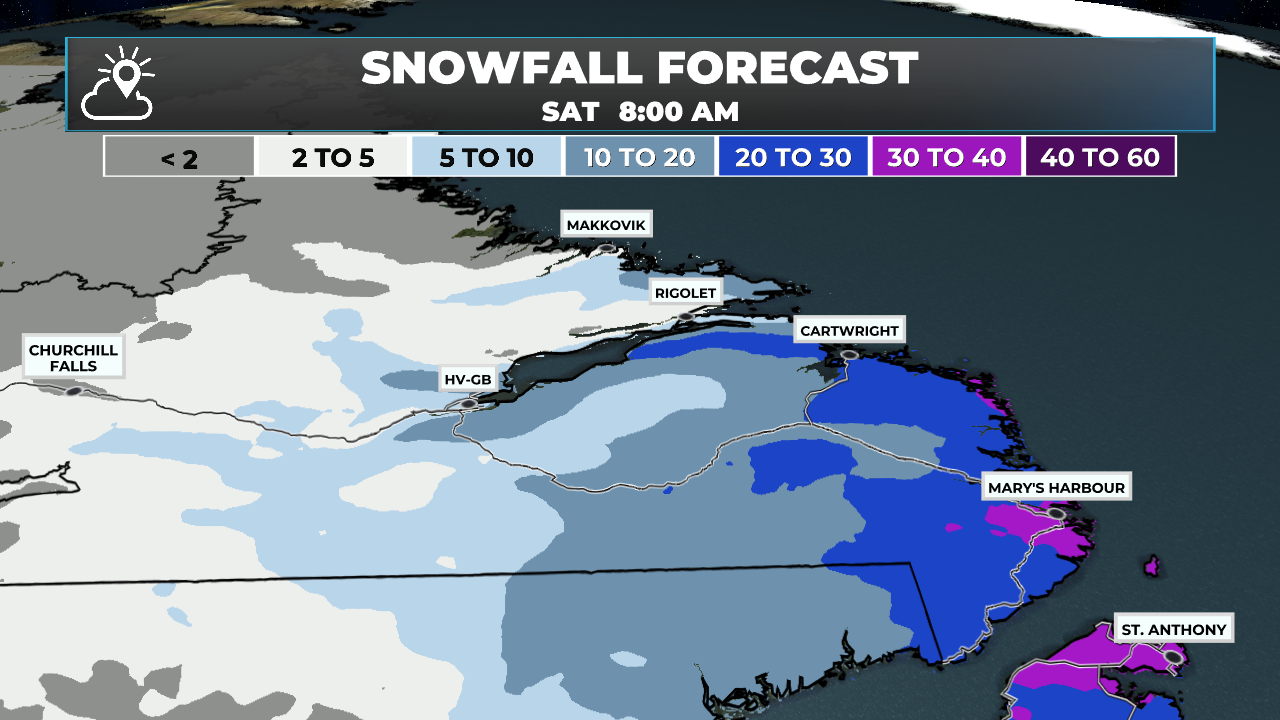
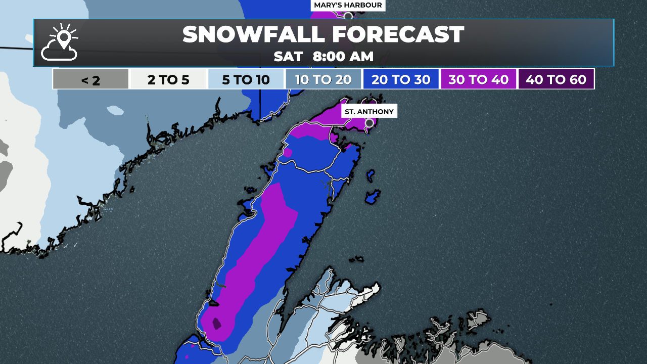
Southeastern Labrador has been glossed over thus far in this post, and for that I apologize. The forecast for that area is the simplest of the bunch; however, that doesn’t mean the weather won’t be impactful. Much of the region remains under an orange-level winter storm warning this morning, which will continue to be in effect until Saturday morning. Snowfall will be heavy at times today and tonight before easing tomorrow morning. Amounts will easily exceed 40 to 50 cm in some locations. Travel will remain difficult due to falling snow and gusty winds. The image below shows the expected snowfall from this morning through tomorrow morning, when the snow is expected to end across Labrador and western Newfoundland.
Speaking of snow… this brings me to my next point. A Special Weather Statement has been issued for much of central and eastern Newfoundland, including the Avalon Peninsula, for Saturday night and Sunday due to the threat of at least 15 cm of snow and wind gusts approaching 70 km/h. Perhaps this is Sheila?
I’ll have more details on today’s weather and what to expect over the weekend today. Be sure to follow along for updates!
FIND ME ON SOCIAL!