
Thursday morning weather brief — August 14, 2025
Good Thursday morning.
The Province will be providing an update on the wildfires this morning (August 14, 2025) at 10 AM. You can watch on the Government’s YouTube Channel or here.
Late last evening, Fisheries, Forestry, and Agriculture, Newfoundland and Labrador put out an update on their social channels on the status of the wildfires in the Province. Here are the highlights from their statement:
Wildfire Update – Key Points (Aug. 13, 2025, 9:30 p.m.)
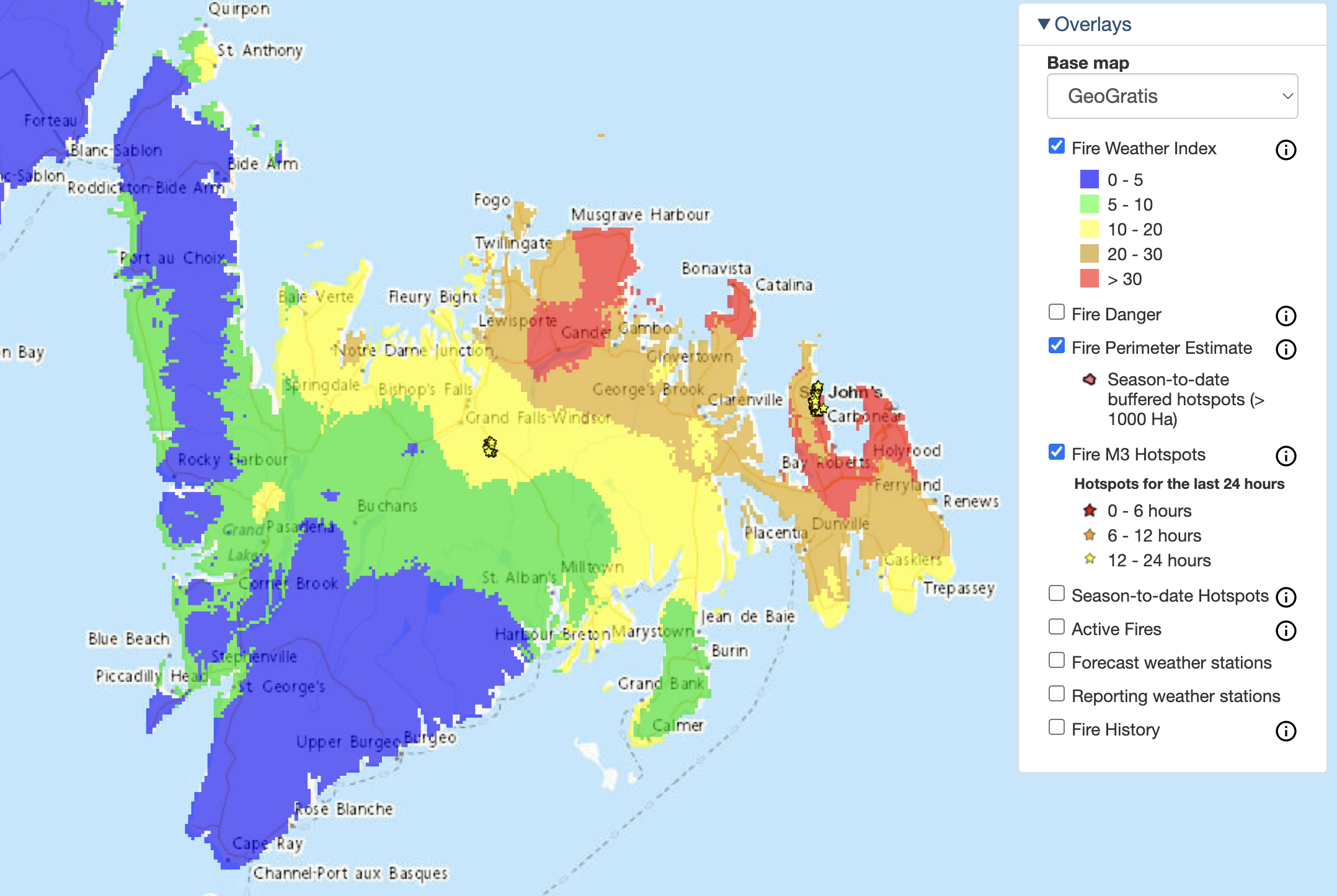
Challenging Conditions – High temperatures, strong winds, and extreme Fire Weather Index continue to make suppression difficult. The province says an Incident Action Plan is in place and crews are working around the clock.
Kingston Fire – Estimated at ~6,500 ha. Extreme fire behaviour today. About 2 km of fuel break completed on the southern edge; work continues tomorrow. Supported by military crews and volunteer fire departments.
Paddy’s Pond Fire – Estimated at ~300 ha. Northern fuel break is complete; work ongoing on east and west boundaries. Air and ground suppression to continue tomorrow. St. John’s Regional Fire Department remains active along the TCH.
Martin Lake Fire – Extreme fire behaviour today; estimated to have doubled in size. Route 360 remains closed. Evacuation advisory for Martin Lake, Great Rattling Brook, and Rushy Pond expanded to include Paradise Lake. All cabin owners advised to leave.
Next Steps – Incident Management Team to reassess tomorrow and set the day’s plan.
Here is the full statement
“WILDFIRE UPDATE
Continued high temperatures, strong winds and Extreme Fire Weather indices continue to make fire suppression very challenging. We want to reassure those impacted by the wildfire that the department has a clear Incident Action Plan in place and continues work non-stop to protect people and communities with all available resources.
Wildfire suppression crews continued to experience extreme fire behaviour at the Kingston wildfire today. The fire is estimated at approximately 6,500 ha. Aerial suppression and ground crews continued to work the southern edge of the fire. Approximately two kilometres of a fuel break were completed today and will also continue tomorrow. Military crews and volunteer fire departments are assisting in the suppression efforts.
The Paddy’s Pond fire remains active with an estimated size of approximately 300 ha. The northern fuel break is complete and work will continue on the east and west boundaries tomorrow. Air suppression and ground crews will continue to action the fire in the morning.
The St. John’s Regional Fire Department continues to provide ground suppression along the Trans-Canada Highway. Residents are reminded this is still a very active fire and to monitor official government sources for updates.
The wildfire in Martin Lake saw extreme fire behaviour today and is estimated to have doubled in size. Route 360 (Bay d’Espoir Highway) remains closed. An evacuation advisory issued for cabin owners in the Martin Lake, Great Rattling Brook and Rushy Pond area and access roads in Central Newfoundland has been expanded to include the Paradise Lake area. All cabin owners in the area have been advised to leave their cabins.
The Incident Management Team will assess conditions and fire behaviour tomorrow to determine a plan for the day. ”
This morning’s update is brought to you by Roebothan, McKay and Marshall.

Visit MakeTheCall.ca for more.
Here are the latest Evacuation Orders and Alerts from the Government of Newfoundland and Labrador.
The Martin Lake fire and the Kingston Fire demonstrated Extreme Fire Behavior (again) yesterday, and I received multiple photos of the smoke plume and multiple reports of smoke being smelled as far north as Twillingate. This satellite view of the smoke plumes yesterday demonstrates this very well.


TODAY’S FORECAST
Wind speeds will be from the south today, and will gust as high as 50 km/h. This direction will act to push the fires toward the north. While there will be an increase in humidity, the combination of hot temperatures and gusty winds will make fire suppression efforts difficult again today. The fire hazard index is above 30 again today for parts of eastern and northeastern Newfoundland. This means the potential exists for more extreme fire behavior.
This will likely lead to more growth, or at least the potential for it, on any fires currently burning on the Island. If you’re in an evacuation alert zone, please pay attention to government officials as an order could come at any time.
Thursday is going to be another hot and humid day across much of the Island and southeast Labrador. Temperatures this afternoon will peak in the mid-to-upper 20s and even the low 30s, with humidex values nearing 40. Heat Warnings are still in effect for much of the Island and parts of southeast Labrador.

We have seen an uptick in the amount of moisture in the air, which should help slow the fires down, even if we don’t see much rain. Speaking of rain, there will be some afternoon showers and thunderstorms over parts of central, interior, and western Newfoundland and the Great Northern Peninsula. Showers will become more widespread in southeast Labrador as a cold front approaches. That front will end the heat in Labrador by tonight and will do the same on the Island tomorrow. However, in the east, we will have to wait until Friday night to see the heat break. Chance for showers and thunderstorms increases on the Island Friday as the cold front swings through. Cooler air arrives for the weekend. Check the app for YOUR areas forecast!
Air Quality will continue to be an issue for areas near and downstream of the fires. The wind direction today will be from the south, which means areas north of the fires will contend with the smell of smoke and poor air quality. Air Quality alerts are in effect for some areas.

The arrows represent today’s wind direction (from the south — blowing to the north)
I’ll have a more detailed look at the longer-range forecast for you later today.
Stay safe.
Eddie