
That Was a Wild One: Howling Winds, Heavy Snow/Rain, and What Comes Next
Let’s face it — it was a long night across Newfoundland and Labrador.
Between the howling winds, heavy snow in some regions, and soaking rain in others, this was one of those classic winter systems that checked nearly every box. Even by mid-afternoon, the coffee was still doing some heavy lifting as I broke down just how intense this storm really was.

This forecast is sponsored by CU Financial Management. Your steady hand—guiding you through every forecast, financial or otherwise.
Visit cufm.ca/forecast today for expert advice.
🌬️ Exceptionally Strong Winds
The standout feature of this system was the wind — and it delivered in a big way. Here are the peak gusts that ocurred with this outbound low.
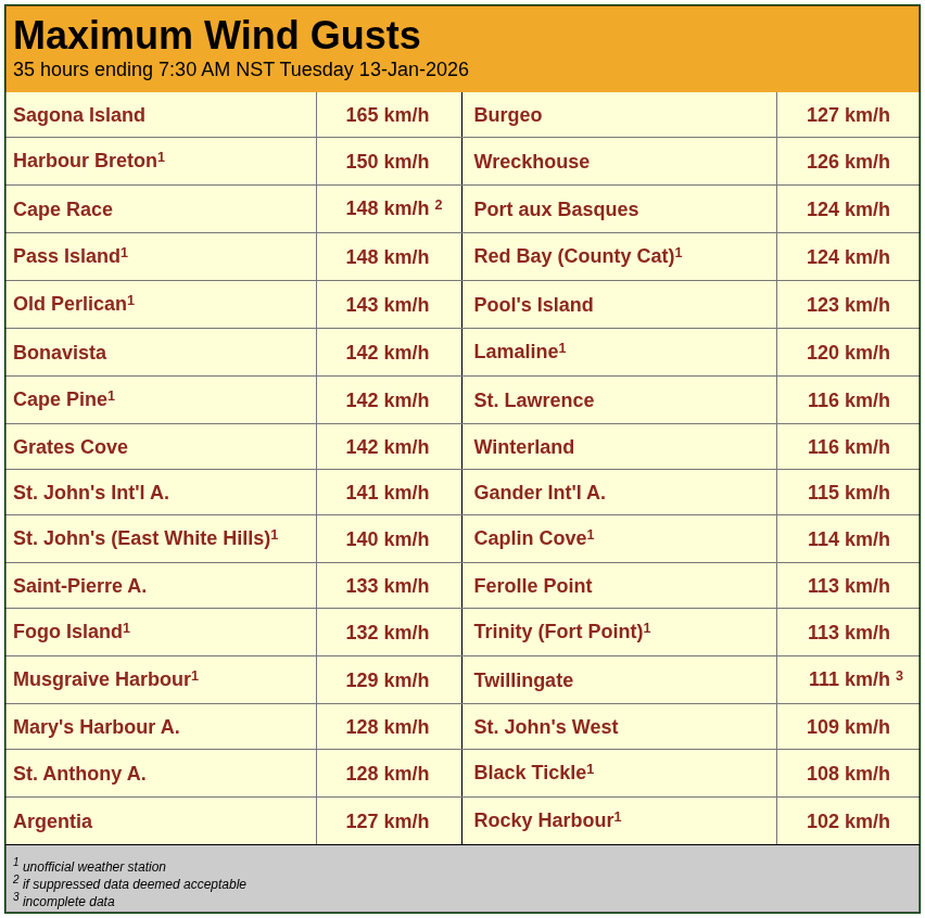
Credit: Rodney Barney
To put this into perspective, St. John’s hadn’t seen winds this strong since December 15, 2025, and before that, you’d have to go back to Hurricane Larry in September 2021.
Unfortunately, the winds also caused damage, including significant roof damage at the Bruce II Arena in Port aux Basques, a vital community facility.
❄️ Heavy Snow in Select Regions
While the wind was widespread, the heaviest snowfall was more localized, focusing on parts of central, western, and northern Newfoundland.
La Scie: 32.5 cm
Twillingate: 31.5 cm
Deer Lake: nearly 30 cm
Badger: 22.7 cm
Stephenville: 21.6 cm
Cormack: 21.6 cm
The Northern Peninsula experienced full blizzard conditions at times, making travel extremely difficult.
🌧️ Significant Rainfall Elsewhere
Meanwhile, areas farther south and southeast dealt with heavy rain:
St. Albans: nearly 55 mm
Winterland: 32.8 mm
St. Lawrence: just under 30 mm
Burgeo: 24.2 mm
Terra Nova National Park: 23 mm
🌀 Why This Storm Was So Intense
This system was powered by an exceptionally deep area of low pressure, dropping into the mid-950 millibar range — very strong by any standard. The sharp temperature contrast between cold air over Quebec and Labrador and much milder Atlantic air helped fuel the storm.
🔮 The Forecast: More Active Weather Ahead
Tonight
Temperatures turn colder, but not extreme
Flurries on the west coast taper off this evening
Wednesday
A dry start for most areas
Rain arrives on the south and west coasts later in the day
Thursday into Friday
A noticeably milder system moves in
Periods of rain for much of Newfoundland
Some wind, but not as strong as what we just experienced
Snow continues for parts of Labrador, with rain possible in the southeast
Looking Ahead
A multi-day thaw sets up across much of Newfoundland
Colder air remains bottled up to the west for now
Signs point to a more consistent cold pattern returning later next week, increasing snow chances again
In fact, it’s one of those patterns where parts of Newfoundland may be milder than sections of the southeastern United States, while very cold air sits just to our west.
📱 Stay Informed
With an active pattern continuing, now is a great time to make sure you have the Sheerr Weather app downloaded from the Apple App Store or Google Play. Frequent updates, alerts, and forecasts help you stay ahead of rapidly changing conditions — and your support helps keep local weather information strong and accessible.
More updates to come as the pattern evolves. Stay safe, and stay weather-aware.
I’ll have my next update posted tomoorrow morning!
📱 Get the Sheerr Weather App in the Apple App Store and Google Play Store.
🗺️ Check out the Map Room to see all the latest weather observations for the Province.
🎥 Check out the Provincial Highway Cams to see 👀 what’s going on around our highways and byways!