
Monday Morning Weather Update — December 8, 2025
Good Monday morning! The day starts quietly, but another area of low pressure brings snow and wind to the eastern half of Newfoundland by this afternoon…
The day is starting pretty quietly across most of the Province this morning. The only thing we are currently looking at is some scattered flurries and areas of onshore snow along and near the Island’s West Coast. This short radar loop below shows that rather nicely.
Radar image from 5:41 AM NST — Taken from the Marble Mountain site. Source: Weather Wise
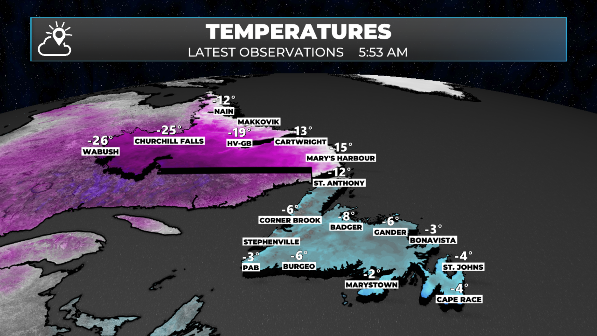
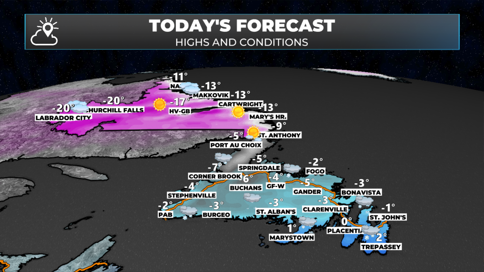
Temperatures vary at this early hour from the minus twenties in Labrador to the minus single digits over the vast majority of the Island. Temperatures will recover today, with minus teens in most of Labrador and minus single digits throughout Newfoundland. Southeastern areas, including on the Avalon, will warm to near freezing later this afternoon or evening as our next area of low pressure moves through.

Our next area of low pressure will move through during the first half of the overnight, and this promises to bring more snow and wind to roughly the eastern half of the Island between this afternoon and early Tuesday morning. Snow will begin to arrive in the southern and southeastern sections this afternoon and will quickly spread north. Forecasts indicate snow will start in the Metro area between 3 and 4 PM. Future satellite and radar (below) should help give you a good idea of when the snow will start in your location. The heaviest snowfall will generally be this evening. We will also be seeing some areas of snow squalls developing along and near the West Coast overnight and on Tuesday.
Snowfall amounts look to be highest, up to about 20 cm, in a swath from near the Grates Cove and Bonavista, southwest through Clarenville and the Terra Nova area, onto the northern third of the Burin Peninsula, and as far west as Connagire. On either side of that expect amounts to be lower, and the farther away from there you are, the less there will be. The map below shows this quite well.
The snowfall forecast from 12 PM today thru 12 PM tomorrow (December 8 - 9, 2025).
Something to note is that there is still some uncertainty with this forecast, and because the snow is in such a narrow swath, a slight difference in the low’s actual track versus the forecast would mean this area is a little east or west of where it’s currently projected.
This update is sponsored by Roebothan, McKay, Marshall.

Visit MakeTheCall.ca TODAY to learn more about what the law firm can do for you.
This low will move through and will also have a core of high winds. Now, this will NOT be anything like Friday night, but the area os the Avalon and Burin Peninsulas, along with the northeast coast, will see two to three hours of winds gusting as high as 100 km/h very late this evening or very early Tuesday morning.
A series of winter storm warnings, blowing snow advisories, snow squall watches, and wind warnings are now in effect across much of Newfoundland as a powerful system moves through the island today and tonight. Snow, strong winds, and rapidly deteriorating travel conditions will be the main impacts. These were issued by Environment and Climate Change Canada earlier this morning.
WINTER STORM WARNINGS
Connaigre is expecting 12–20 cm of snow through midnight, with gusty easterlies shifting to stronger northerlies up to 90 km/h this evening. Roads and visibility will deteriorate quickly.
For Clarenville, Terra Nova, and the Bonavista Peninsula, 15–20 cm of snow is expected late this afternoon through tonight. Winds will shift to strong northwesterlies with gusts up to 110 km/h along exposed coastlines. Brief blizzard-like conditions are possible this evening.
BLOWING SNOW ADVISORIES
Burgeo – Ramea will see 5–10 cm and northerly gusts near 70 km/h, with visibility dropping sharply once the winds strengthen.
Blowing snow advisories are also in effect for Buchans and the Interior, Bonavista North, and Gander and vicinity, where 10–15 cm combined with 60–90 km/h northerly gusts will create widespread blowing snow and hazardous travel.
The Avalon Peninsula North, St. John’s, and the Burin Peninsula will see blowing snow late this evening into the overnight, with northwesterly gusts of 80–110 km/h leading to near-zero visibility at times.
SNOW SQUALL WATCHES
From Channel-Port aux Basques to Corner Brook, the Bay of Islands, and Deer Lake – Humber Valley, conditions become favourable tonight and Tuesday for intense, localized snow squalls. These bands could produce 10+ cm in short bursts and cause sudden whiteout conditions.
WIND WARNINGS
A wind warning continues for the Avalon Peninsula, where west to northwesterly gusts of 80–110 km/h are expected late this evening and overnight. Localized power outages are possible.
Overall, expect rapidly changing conditions, hazardous travel, and pockets of near-zero visibility across multiple regions through tonight. If you don’t need to be on the roads, tonight is a good night to stay put.