
Monday Morning Weather Briefing — March 16, 2026
Good Monday Morning!
Here are today’s weather highlights:
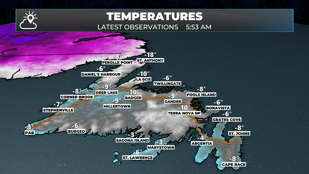
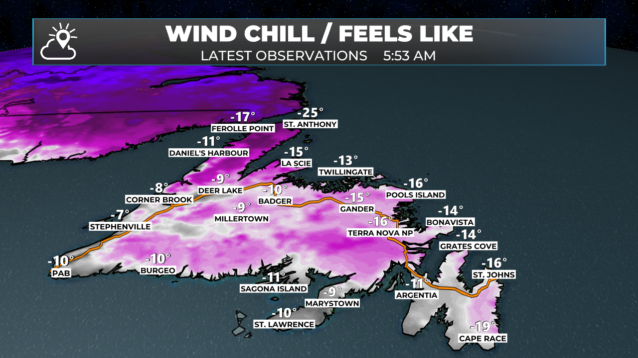
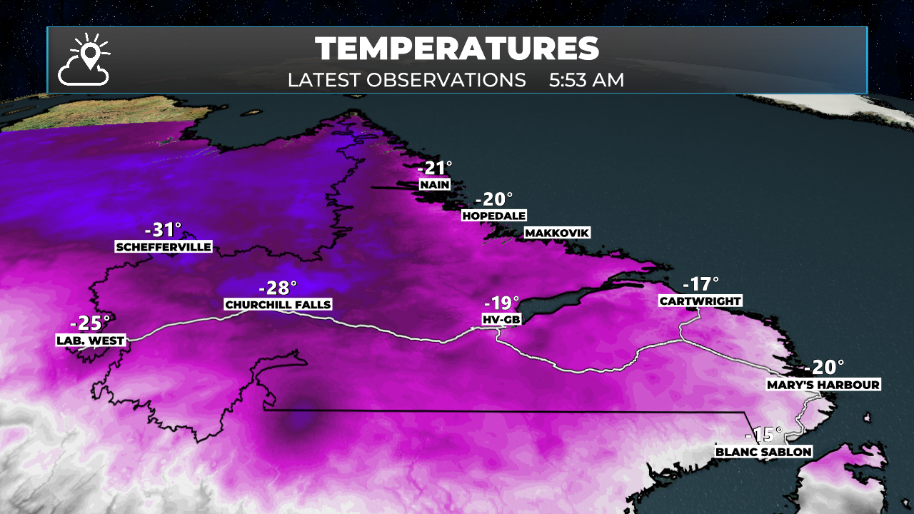
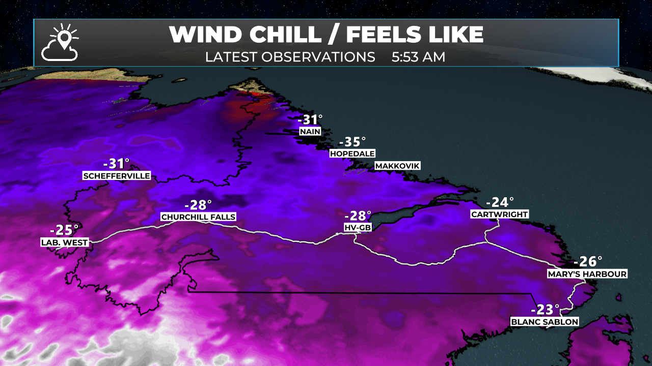
It’s a cold start this morning across NL
Monday will be quiet on the Island with increasing cloud cover
Snow arrives in Labrador West this morning and spreads east throughout the day and evening
A strong storm system tracks WEST of NL tonight and Tuesday and will bring snow, ice, rain, unseasonably warm temperatures and a flash freeze to the Province as it moves through. Special Weather Statements, Rainfall Warnings (Newfoundland), and Snowfall Warnings (Labrador) are currently in effect. Tap view all on the red bar above to see the latest alerts!
Calmer and cooler weather returns for Wednesday
Today’s Forecast for Newfoundland & Labrador
Snow will arrive in Labrador West this morning and steadily push eastward throughout the day. By late afternoon or early evening, the snow will have reached Upper Lake Melville, and early evening, much of the coast will be seeing it as well. Snowfall rates in Labrador West will generally increase through the day as the area of low pressure bringing the precipitation moves closer.
Wind speeds will also increase, and travel will become more difficult across the Big Land as today progresses, especially tonight. Temperatures will generally rise from the upper -10s and -20s this morning to the -10s this afternoon and evening, then rise further overnight.
Labrador's forecast (high temperatures and conditions) for today; March 16, 2026.
Meanwhile, on the island, the forecast is much easier today. Expect partly cloudy to mostly sunny skies this morning and increasing cloud cover this afternoon. Temperatures rebound from the cold start this morning, reaching near freezing in the east and generally in the single digits below freezing elsewhere.
Newfoundland’s forecast (high temperatures and conditions) for today; March 16, 2026.
The Next Storm…

The next storm system is already swirling to our southwest and is bringing severe weather to parts of the southeastern US and a blizzard to parts of the Great Lakes and Ontario. This is a monstrous system that has tapped into very warm temperatures on both the south and north sides. As this moves northeastward, it’s going to bring a mixed bag of significant weather to the Province beginning in Labrador West this morning, and the rest of NL later today and tonight. It will continue to be with us into early Wednesday.
For the Big Land, expect snow to become widespread and heavy at times today and tonight, then change to rain later tonight or Tuesday morning. Snowfall amounts vary, with as much as 15 cm on the coast and 20 to 25 cm in the west. After the snow, a substantial but short-lived warm-up will follow, with much of the area rising to near 10º at various times Tuesday as warmer air surges northward on the east side of the low. Tuesday afternoon will see cold air come crashing back into Larador West before quickly marching eastward across the rest of the Big Land before Wednesday morning. The sudden drop in temperatures will bring a flash freeze, meaning standing water will freeze very quickly, making travel and moving around very difficult. It will also be quite windy Tuesday into Wednesday.
The hourly temperature forecast for tomorrow (March 17, 2026) in Labrador West
On the Island, a brief bout of wintry weather will roll in tonight ahead of the warm air, and most of us will see a couple of hours of snow going to ice pellets and freezing rain before the change to rain by Tuesday morning. Tuesday will be unseasonably warm across the Island (with highs in the mid-to-upper teens) and windy. Expect widespread gusts of 60 to 80 km/h from the southwest. The forecast image below shows highs in the lower teens tomorrow; however, the displayed data may be a bit too cool given the setup.
There is a chance that areas of central and northeastern Newfoundland and even parts of the Avalon will get to 15º+ tomorrow with a bit of sunshine.
Newfoundland's forecast for tomorrow - March 17, 2026
Showers and pockets of rain will be widespread; however, the heavy, steady rain looks to be limited to the South Coast for much of the day. It will expand northward later Tuesday and Tuesday night as the cold front moves through, ending the rain from west to east by Wednesday morning for all areas except in the east, where the rain will not occur until mid-morning Wednesday. Temperatures fall sharply on Wednesday as a cold front returns to well below freezing.
The rainfall forecast from later today through Wednesday morning (March 16 - 18, 2026)
I’ll have a more detailed forecast later today!
FIND ME ON SOCIAL!