
Monday Morning Weather Brief — November 3, 2025
WIND WARNINGS, SPECIAL WEATHER STATEMENTS AND COASTAL FLOOD ALERTS ARE IN EFFECT FOR NL. TAP HERE TO SEE THE LATEST ALERTS FROM ECCC
...
WIND WARNINGS, SPECIAL WEATHER STATEMENTS AND COASTAL FLOOD ALERTS ARE IN EFFECT FOR NL. TAP HERE TO SEE THE LATEST ALERTS FROM ECCC ...
Good Monday morning!
Here are some highlights to know as we start the new week:
The weather across NL will be quiet today.
A rapidly strengthening area of low pressure will move up from the south on Tuesday, move over the Island Tuesday night, and enter the North Atlantic on Wednesday.
This low will bring:
Heavy rain to much of Newfoundland and coastal Labrador. Heavy snowfall is expected in the higher terrain of central and western Newfoundland, as well as southeastern Labrador.
High wind gusts are expected in the area of southeastern and eastern Newfoundland on Tuesday afternoon, night, and Wednesday, with wind gusts exceeding 100 km/h and possibly as high as 120 km/h in some areas.
Storm surge and large waves to southern shorelines with Tuesday evening’s high tide and northern shorelines with Wednesday morning’s high tide. Coastal Flood Alerts are in effect.
At this time, there is some uncertainty about where the highest storm may be on Tuesday evening, as it will ultimately depend on the track of the low-pressure centre as it nears and makes landfall on the Island.
The weather on the Island will improve (slowly) on Wednesday behind the departing low, while coastal Labrador will see rain and snow into Thursday or Friday as this system stalls in the North Atlantic.
Another low will track south and east of Newfoundland Thursday into Friday… as has the potential to bring snow to parts of interior and central Newfoundland. We will deal with this later…

Today will see tranquil weather in advance of the incomoing storm. Expect highs in the single digits across the Province under a mix of sun and cloud. Clouds begin to increase later today. High temperatures reach the lower to middle single digits for most areas today. Today will be a great day to prep for tomorrow’s wind… and possible storm surge if you’re in a coastal area and have interests along, near and on the water.

Today’s forecast | November 3, 2025
Tomorrow (Tuesday) morning will start quietly, but that will change as the morning goes on. Rain will reach most areas by midday, and wind speeds will increase in the afternoon and evening, remaining high in the east into Wednesday morning. Snow will develop in the higher terrain on Tuesday night and continue into Wednesday morning. The weather will gradually improve for most by late Wednesday.
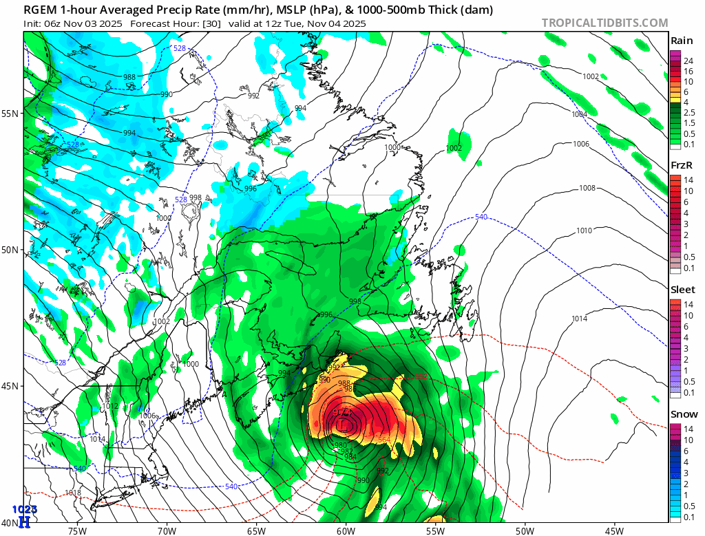
An animation of how the low will develop and cross southeastern Newfoundland Tuesday night | November 4 - 5, 2025
I’ll have a much more thorough update on the incoming storm and the forecast for this week later today. In the meantime, be sure to download my app on your phone or tablet to receive the latest updates via push alerts, as well as the most current weather alerts and forecasts for your exact location. And be sure to follow me on social media to get more frequent updates than I post on the website. I’ll also be live-streaming during this event, so look out for those details on Facebook and YouTube.